By Van Smith
Published in City Paper, Apr. 17, 2013

My trusty handheld GPS helps keep me safe while kayaking, letting me know precisely where I am on a map. But bringing it along on kayaking trips, it turns out, can serve more than my own personal safety: It’s also a useful tool to map the land-devouring effects of sea-level rise in the Chesapeake Bay.
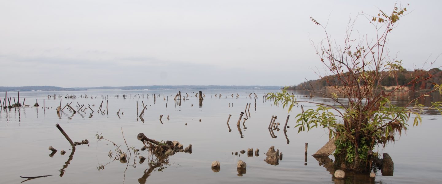
On April 21, 2007, I kayaked around James Island (pictured), at the mouth of the Little Choptank River, in Dorchester County on Maryland’s Eastern Shore. The outing, for which I made camp at the nearby Taylor’s Island Family Campground, was part of my research for an article about exploring the Chesapeake Bay’s vanishing islands (“Wetlands,” Feature, May 23, 2007), about 40 of which oceanographer William Cronin had chronicled in his 2005 book, The Disappearing Islands of the Chesapeake.
As Cronin pointed out, sea-level rise in the bay had been estimated at 3 feet per millennium until about 1900, but then, over the course of the 20th century, a 1-foot rise was observed-an acceleration that washed away at least three notable islands and was eating away at the rest.
As I circumnavigated James Island in 2007, hugging the shoreline as closely as possible while dodging fallen pine trees partially submerged in the murky water, my GPS recorded my route, laying it out like a bread-crumb trail on its map. In the end, I’d mapped the contours of the island’s shore-or, rather, the coastline of its three islets, since James is no longer a single island.
The shoreline here is virtually free of gradually sloping beaches and instead ends abruptly with short, precipitous drops into the drink. The small cliffs have been left behind after chunks of land fall into the bay as it erodes, similar to the way melting glaciers lose pieces of their mass in a process known as “ice calving.” Thus, the bay’s tides, rather than going in and out along the shoreline, covering up and then exposing the intertidal zone, go up and down vertically along the bold shore, allowing a shallow-draft craft like a kayak to stay quite close to land regardless of when in the tide cycle one is paddling.
James Island used to be populated as recently as the early 1900s, with 20 houses, a school, a boatyard, a church, and a cemetery. Studies have described its inexorable and ongoing destruction: from 975 acres in 1848 to 72 acres in 2006, losing an average of 5.7 acres annually over the course of those 158 years. A return trip with my GPS would allow me to estimate its land loss in the past six years and calculate whether its rate of loss was more or less than the historical record indicated.
Also in 2007, I gunk-holed around the nearby coast of Taylor’s Island, lingering close to a farmhouse at the northern mouth of Oyster Cove that was precariously close to falling into the bay, and noting the ochre cliffs, 6-plus feet high, that had formed as farmland had been shorn off in great chunks by the force of incoming waves. A return trip with the GPS could provide me with a rough indication of how much more farmland had been lost to the bay’s rising waters-though the fate of the house would be a matter of simply using my eyes.
First I paddled from the campground on Taylor’s Island to the Oyster Cove farmhouse, which is now reduced to a pile of rubble. My GPS indicates I paddled on water about 100 feet inland from where I’d been in 2007-a feat only possible due to a significant sacrifice of farmland to Neptune. When I had asked about this earlier at the campground, an old-timer estimated about 30 acres of this farm had fallen into the bay in the last five years or so-as reasonable a guess as any, I suppose, given that the bay’s now 100 feet further inland.
I headed out from the Oyster Cove point to the southern tip of James Island-a stretch that has lengthened in the past six years, according to my GPS. It’s now a 0.6 mile trip, about 530 feet more than it was in 2007, yet another measurement of vanished land. Then I paddled around the three islets, forming another GPS bread-crumb trail that, when compared to the one laid down in 2007, indicates 67 percent of James Island’s land has succumbed to the Chesapeake’s tides in six years. The rate-6.2 acres per year-is a half-acre more than the average annual rate of land loss over the 158 years prior to 2006.
CP’s webmaster Andrew Vogel took the GPS locational data from my two trips around James Island, imported it into Google Earth, and used the software to create two shapes for each island, one for 2007 and the other for this year. Google Earth then automatically calculated the area for each of the shapes, providing precise measurements to determine how much land James Island lost in the intervening six years.
The results are striking: 37.3 acres have been lost, leaving behind a paltry 18.3. The middle island suffered most, losing at least 16 of the 21 acres it had in 2007.
Based on the GPS coordinates recorded during my two paddling trips, two broad conclusions about the James Island coastline are clear: The bay’s rising waters are claiming its land, and they are claiming it faster than in the past.
Turns out, that’s not surprising. Last year, two groups of scientists published research indicating not only that the mid-Atlantic coast’s sea level recently rose significantly faster than the global average, but that its rate of rise in the Chesapeake Bay is accelerating.
James Island is “like a canary in a coal mine,” says Court Stevenson, a professor at University of Maryland’s Center for Environmental Science in Cambridge and a long-respected expert on sea-level rise’s impacts on the bay’s shores. He recalls going to James Island about 15 years ago and tagging 100 pine trees whose circumference he intended to measure to determine their rate of growth. “We went back a year a half, two years later, not a tree was standing. They were all gone-100 of them. Basically, our whole study was gone.
That kind of rapid land loss, especially if it quickens with an acceleration of sea-level rise, may well foretell the story of the Chesapeake Bay coastline’s future.In 1914, J. Fred. Hunter of the U.S. Geological Survey (USGS) studied several of the Chesapeake’s fast-eroding islands near the Choptank and Little Choptank rivers, including James Island. After chronicling the land-loss facts based on available evidence, Hunter hazarded a guess: James Island “should disappear in about 150 years,” while adding the blanket caveat that “numerous other factors may enter to disturb the present conditions and rate of erosion.”
Interestingly, should James Island’s land-loss rate of the past six years continue apace, Hunter’s prediction that it will have vanished by 2064 would prove quite prescient. If it continues to lose about 67 percent of its acreage every six years, by 2064 only a third of an acre would remain.
Since I can’t paddle over land, and wasn’t willing to trespass on the Oyster Creek farmland to walk the edge of its cliffs with my GPS, it’s anybody’s guess how much of its acreage has been lost-and how much more will calve off into the bay in the future. But more will; as James Island’s destruction continues, the shore it protected from the waves will take ever-worse beatings and more direct hits by wind-driven waves.
Meanwhile, Hunter’s caveat in making his prediction about James Island’s disappearance-the “other factors”-recently entered into play. The fact that the Chesapeake region’s land continues to subside, thanks to a combination of long-term regional settling of the Earth’s crust after the glaciers last melted, starting about 18,000 years ago, and the more recent drawing down of groundwater as population swelled, only compounds the sea’s accelerating encroachment on land. And that encroachment, based on recent science, is becoming more and more worrisome.
In a paper appearing last June in Nature Climate Change, USGS researchers identified a 1,000-mile long “hotspot” on the East Coast between Cape Hatteras in North Carolina and just north of Cape Cod in Massachusetts – which includes the bay – where sea-level rise has accelerated at three to four times the global average over the last 20 years. This discovery was followed in October by a Geophysical Research Letters paper by a two-man, British-American team of oceanographers who found that the bay’s sea-level rise may have sped up from 1 to 3 millimeters per year in the 1930s to 4 to 10 millimeters per year so far in the 2000s. If the 10-millimeter high end holds true in the future, then the bay’s water will rise a little bit more in the next 100 years than it did in the 1,000 years prior to 1900.
In short, scientists recently started to detect a “hockey stick” shape to the sea-level-rise curve for the Chesapeake Bay, which would spell faster-arriving impacts from the already-expected inundation resulting from climate change. No wonder, then, that James Island’s land loss has been appreciably faster in the last six years than in the preceding period back to 1848. It’s just one example of a near-endless litany of anxiety-inducing repercussions that faster-rising seas are expected to have on the bay.
Stevenson, who says he first came to live on and study the bay in 1972, says that “when I first started talking about sea-level rise, people thought it was just sort of flat-it was increasing but it wasn’t accelerating. But now it is inflecting upwards, and that spells trouble. You just get much more erosion since the water level is higher and higher in the flood plain, and the wave attack is much, much higher, and places that once were underwater only a few hours a day get inundated much more of the day, so they just keep getting this wave action that just keeps beating on it. If sea level is inflecting upwards, then it’s all just going to happen a lot quicker than we had seen in previous centuries of sea-level rise. And that, in a nutshell, is what a number of us who are concerned about sea-level rise are worried about.”
Not surprisingly, such worries have been getting high-level attention.
On Dec. 28, Gov. Martin O’Malley (D) signed an executive order that, had it been read at the time by Marylanders trying to enjoy a holiday break from their routines, would likely have caused some to choke on their eggnog.
It’s purpose was dry enough-that state agencies incorporate the risk of inundation from coastal flooding and sea-level rise into all planning for future state-capital projects, that agency construction projects be built at least 2 feet above the 100-year flood line, and that additional recommendations for safely building or renovating state structures in light of sea-level rise be devised quickly. But its preamble-the “Whereas” section-cited the recent USGS “hotspot” study to tick off a list of current and anticipated problems sea-level rise entails. Among them were:
-“The State of Maryland is currently losing approximately 580 acres every year to shore erosion.”
-“Alarmingly, thirteen Chesapeake Bay islands once mapped on nautical charts have been lost.”
-“Future changes in sea level threaten to increase the State of Maryland’s vulnerability to storm events, causing more shore erosion and severe coastal flooding, inundating low-lying lands, submerging tidal wetlands and marshes, and resulting in additional salt-water intrusion, and high water tables.”
-“The State of Maryland has approximately 450 existing State-owned facilities and 400 miles of roadways within areas likely to be impacted by sea level rise over the next 100 years.”
-“Billions of dollars of investments in public infrastructure will be threatened if the State of Maryland fails to prepare adequately for climate change.”
In the neighboring state of Delaware, Gov. Jack Markell (D) got into the act in January, with a “state of the state” address that envisioned a future so threatened by rising seas-and especially the hurricanes that come with them-that the time has arrived to do triage on what can and cannot be protected. Calling last fall’s Superstorm Sandy a “wakeup call,” Markell said that Delaware must start “strengthening dikes and dams, conserving wetlands, improving drainage, or nourishing beaches,” but “the need for this infrastructure exceeds the resources available,” so the state must have a “frank conversation” about how to “prioritize and finance projects, so that we protect what we can and make realistic choices about what we cannot.”
There have long been such frank conversations about restoring the bay’s vanishing islands with dredging spoils, 3 to 4 million cubic yards of which are scooped out of the bay’s channels each year to keep the Port of Baltimore accessible to ships. Since 2006, James Island has been one of the islands selected to be built back up this way, as part of something called the Mid-Chesapeake Bay Island Ecosystem Restoration Program, which would provide new uplands and wetlands as wildlife habitat and also recreate a buffer to help protect the Little Choptank River coastline from ongoing loss of land. But other than studies-many of them have been conducted, providing a wealth of details about James Island’s history, ecology, and geology-there’s been no further action.
The project is “unfortunately stalled,” says Maryland state Del. Jeannie Haddaway-Riccio (R-District 37B), who represents several bay-facing Eastern Shore counties and strongly supports the program. The reason, she says, is that it relies on “federal money that has not been dedicated other than to planning.” Still, she stresses the need to “shore up those islands” to provide a buffer for communities and landowners to the east.
“The longer we put it off,” she says, “the more expensive and harder it is to rectify.” She says that on Hooper’s Island, just south of Taylor’s Island, “gravesites have been going into the water” and notes that “it’s amazing, the cliffs that have been created” by the gouging action of the waves hitting the shore.
At Taylor’s Island Family Campground, owner Bruce Coulson has a front-row seat to the damage wrought by sea-level rise. He and his group, the Dorchester County Shoreline Erosion Group, have long promoted ways to reduce the force of the waves pounding the shoreline in these parts so the bay’s increasingly ravenous appetite for nearby land will be slowed. He has good reason: The bay’s been stealing away his land-though not as fast as it’s been taking it from other nearby landowners, thanks to the huge chunks of concrete he’s placed along his shoreline. Each weighs 15,000 to 20,000 pounds, he estimates, yet the waves of Superstorm Sandy still managed to move them. Of the 15 acres of land that once comprised this parcel, 11 remain. “The other four is out there in the bay,” he says.
The land loss on Taylor’s Island and other parts of the Little Choptank River waterfront, including a lot of farmland, “just keeps adding pollutants and nutrients and sediments to the bay,” he says. “It’s terrible. It’s chewing off everything. You can sit there and do all you want to clean up the bay, but until you control something like this, you’re just not doing the job.”
One option, he says, is offshore breakwaters to reduce the force of the waves hitting the shoreline. Do that, he says, and coastal property owners might stand a chance to establish “living shorelines” that are being promoted as an environmentally sustainable alternative to lining the shore with heavy rocks. If there were breakwaters, which he estimates would cost about $70 million, based on studies from the late 1990s, “then you can probably put in your living shorelines up and down the bay, but you’ve got to stop that force from coming at you first.”
Another idea Coulson tosses out concerns the imminent problems at Conowingo Dam on the Susquehanna River, which since the 1920s has been holding back huge volumes of sediment that otherwise would have entered the bay. It is nearing capacity, and when it does, new sediments coming down the Susquehanna will simply enter the bay unimpeded, unless something is done. “They’re talking about dredging it,” he says, “and I’m thinking, put it all on barges and dump it off at James Island.”
“If you put that island back in there, you’ve built a breakwater,” Coulson says. Without it, he says, “when James Island is completely gone, up here at Oyster Cove it’s going to really nail us with the northwest wind. There’s farmland that’ll go, but what’s next is the road, and then the county’s going to have to spend a lot of money.”
Until something is done, though, Coulson’s campground will continue to take a beating, protected by the concrete chunks. Erosion has gouged out a cove just south of his property, and during a visit, a stiff breeze was slamming waves relentlessly into the roots of the adjacent pine forest. The bay’s water was thick and gray with sediment, which was being carried northward in discolored tidal currents as downed pine trunks pounded around in the surf.
This is what active, everyday erosion looks like, and it’s not pretty. It looks like what it is: pollution. As the seas continue to rise, scenes like this will become more and more commonplace along the bay’s shores, eating away land and further undermining the bay’s health.
Stevenson knows Coulson and says he “has a lot of good common sense, and he’s a good observer.” But Stevenson is not as sold as Coulson is that rebuilding James Island or building offshore breakwaters is a solution. “I don’t think we can solve it,” Stevenson says of the inexorable erosion caused by winds and waves carried by rising seas. While agreeing that the active loss of large amounts of farming may be a serious pollution issue for the bay-“there’s a lot of nitrogen and phosphorous associated with farmland,” he says, “and 30 acres has a lot of nitrogen and phosphorous that’s going into the bay, as well as the sediment itself that makes the water murky”-he’s essentially gloomy about the whole problem. “We might be able to protect some things and slow it down,” he says, “but I don’t think there’s a fix.”
The bleak outlook seems uncharacteristic for a man whose career has been dedicated to finding smart ways to reverse the long decline of the bay’s ecological health. Yet there it is: “I think that we’re just going to get submersion of land,” he says. “And we’re just going to see more open water.” He holds out a depressing fact for consideration: “We’ve looked at how much marsh is being formed versus how much we are losing-for every 10 acres that we’ve lost, we’ve only gained one over the last 30 years. I’m pessimistic.”
The very real prospect of climate change driving sea-level rise at a quickening pace, and more so in the bay than most other parts of the world, has Stevenson very worried, and he wonders about the wisdom of attempting to concoct technological fixes for the symptoms rather than treating the disease, which he says is clear: the rise in greenhouse-gas emissions, especially carbon dioxide, in the modern era. “If you really look at the expense for the whole Eastern Seaboard and maybe part of the Gulf Coast” for preparing for more rapidly rising sea levels, “it’s maybe better to do something about containing greenhouse gases. But that argument doesn’t seem to have much resonance.”
Major hurricanes – not like Isabel in 2003 or Agnes in 1972, but ones like the one that stormed up the bay in 1938 and is etched in the Eastern Shore’s collective memory – are what make Stevenson “pull my hair out with worry,” he says. “It’s just a matter of time” before one hits, he says, “and it really will be formidable. There’s a lot of places that now exist that won’t. Baltimore is not immune either, with the surge amplified as you go up the bay. It may come in at 3 to 5 feet at the mouth of the bay, and reach 10 feet as you get up to Baltimore. Sea-level rise keeps adding to your base water level, and then you get the storm and what used to be a problem is now a mega-disaster.”
The technological fixes for that kind of threat are truly huge public-works projects, he says, and he has at times brought them up, “arguing that maybe we really start to think about a tidal gate” across the Patapsco River. “That’s what it’ll take, if you really want to keep the infrastructure that you’ve got around the Baltimore harbor, especially if we get this acceleration in the sea-level rise,” he continues, “but it’s billions of dollars for something like that, and then you have Annapolis and Norfolk to worry about too.
“We’re on the edge of a major change, I think, and it’s almost getting to be inevitable,” he continues. “Even the bay cleanup, I think, is at risk, because you see all the pollution just from the erosional processes that we’re going to have to take care of, even more so than in the past, and I don’t know if we can really spend that much money on it. I don’t know what the willingness to pay is to keep the bay in good shape, as global warming and sea-level rise really has a major, growing impact, and I think it’s going to get harder and harder to control the forces we’re unleashing.”
Like most people, Stevenson says he “would like to leave something for the next generation, and I always thought that we could make a big dent here, in terms of cleaning up the Chesapeake Bay.” In the early 1980s, when the bay cleanup program really got into gear, “I thought at that point, Well, they’re probably a little trigger-happy, trying to do too much too quickly. But I thought we had a chance to make a dent. After 30 years, I’m not so sure right now. I think sea-level rise is going to bite us in the ass.”
By the time that happens, James Island will likely have already been bitten out of existence. As long as it’s still around, though, its shrinking, sinking acreage can serve as a reminder that, at the very least, people and leaders around the bay need to prepare for an increasingly inundated future.

2 thoughts on “Aquageddon: A disappearing island shows what rising sea levels mean for the Chesapeake Bay”