Weather Retort: Is Maryland in for Doom and Gloom on the Climate Front?

By Van Smith

First published in City Paper, Nov. 20, 1996

“Everybody talks about the weather, but nobody does anything about it.” The stock of that famously pat phrase, often attributed to Mark Twain, has been dropping of late. As about 300 scientists from the world over agreed last year during a United Nations conference on world climate in Rome, “The balance of evidence suggests a discernible human influence on global climate.”

According to worldwide measurements, that climate is changing. In terms of temperature, the group concluded, the Earth is heating up faster than it has at any time in the past 10,000 years. Twain be damned, we are doing something about the weather, whether we mean to or not.

The scientists’ statement, made in a report issued but the Intergovernmental Panel on Climate Change (IPCC), suggest we are suffering from an inadvertent form of hubris: By existing in ever larger and technologically advancing numbers (as humans are wont to do), we may be setting in motion our own demise. The distant past tells us that a significantly changing climate causes great transformations in life on Earth. In the modern world, with its unprecedented population growth and rapidly developing, large-scale patterns of human settlement, great social upheaval is likely to follow any critical changes in global climate. Indeed, minor climate fluctuations in the past have coincided with periods of social and political upheaval. If some of the current predictions of global climate change – shaky though they are – prove correct, the world will become a very uncomfortable place indeed.

In May, the World Meteorological Organization (WMO) issued its annual “Statement on the Status of Global Climate,” revealing that 1995 was the hottest year since reliable worldwide temperature recording began in 1861. WMO’s findings buttress the scientific consensus of the 1995 IPCC report, which concludes that over the last 100 years the mean global temperature over land increased by nearly one degree Fahrenheit, over sea by nearly 1.3 degrees, and in the deep ocean by nearly two degrees; that sea level has risen by between one and two centimeters per decade; and that carbon dioxide in the atmosphere has increased nearly 30 percent. Nine of the 10 warmest years in the 100-year period have occurred in the past decade, the group found.

The IPCC, the 300 or so delegates of which represent the collective wisdom of 2,500 climate experts, also made projections about future global climate change. By 2100, the group predicts, the mean global temperature will rise been 1.8 and 6.3 degrees Fahrenheit, and the sea level will rise between six and 37.5 inches; the panel’s “best estimate” is a 3.6-degree warming and a nearly 20-inch rise in sea level. It also predicts more storms and droughts, both of greater intensity. These and other climatic changes, the panel says, will have a grave impact on agriculture and forestry, ecosystems, water resources, human settlements, energy, transportation, industry, human health, and air quality, among other things. The IPCC’s projections present an alarmingly bleak picture of a fast-changing future environment.

Given the potential hazards of climate change, Marylanders would be well-advised to start thinking about the possible consequences for the Free State’s people, economy, and ecosystems. But there’s a problem here. Reducing the predicted global phenomenon to the regional level, then reducing it further to the state level, is a complicated matter.

Unless there’s a bevy of researchers we weren’t able to locate, it appears that Maryland’s scientific brain trust has achieved little in nailing down the specific implications of climate change for Maryland, although some promising work is underway. Instead, scientists studying Maryland’s climate have been concentrating on pinning down the truth about what’s already occurring: climate change tied to urbanization and a rise in the level of the Chesapeake Bay.

But, as Bob Dylan sang, “You don’t need a weatherman to know which way the wind blows.” A review of Maryland’s recent weather extremes and odd meteorological events makes the casual weather watcher wonder: Are the global changes currently causing any local change? And if so or even if they aren’t – what should we in Maryland do about the prospects of climate change?

The theory of global climate change rests on the “greenhouse effect,” a known phenomenon in which atmospheric gases – primarily carbon dioxide, methane, and water vapor – trap heat from the sun and keep it near the Earth’s surface. The service these gases perform is essential to life; they keep the Earth more than 60 degrees warmer than it would be without them.

The question is, what happens when the atmospheric concentration of greenhouse gases rises? Research by paleoclimatologist, who study ancient weather patterns, indicates that in the planet’s distant past, temperatures rose as greenhouse gas concentrations increased. Since human activities are causing rapid increases in all greenhouse gases, there is good reason to be concerned about the possibility of human-caused climate change.

Knowledge of the human influence on global climate has been building during the entire century-and-a-half history of modern industrial development. The greenhouse effect was first proposed and studied by European scientists in the mid-19th century. In the late 1800s scientists first theorized that industrial processes, by burning carbon-based fossil fuels, are probably increasing carbon dioxide concentrations in the atmosphere. Then, at the turn of the century, Svante Arrhenius, a Swedish chemist, calculated how much temperatures were expected to increase as carbon dioxide increases. By 1900, most of the pieces of the carbon dioxide/climate puzzle were already in place.

“Nevertheless,” William Kellogg of the National Center for Atmospheric Research (NCAR) in Boulder, Colorado, wrote in a 1987 article in the scientific journal Climatic Change, “the intriguing idea that mankind could raise the earth’s temperature seems at first to have attracted surprisingly little attention in the scientific community and even less in the public media.” It was not until 1957, when two scientists at the Scripps Institution of Oceanography wrote an article proclaiming, “Human beings are now carrying out a large-scale geophysical experiment” by testing the greenhouse effect, that science and the public began to wise up to the potential for climate change. In 1965 the U.S. government for the first time publicly recognized the human contribution to the greenhouse effect.

Public concern picked up rapidly after a series of climate-related disasters took a tragic toll on human life and world food supplies. Crop failures in the Soviet Union and India, severe drought in Africa, fishery collapses in South America, poor U.S. corn production, and major droughts in the United States and Europe all occurred in the space of four years, causing widespread famine and agricultural losses estimated in the billions of dollars.

Ironically, much of the resulting anxiety focused on one climatologist’s theory that the disruptions were due to the advent of a new little ice age, as evidenced by a 30-year cooling in Northern Hemisphere temperatures and supported by the assertion that, according to our knowledge of past climates (gained by the efforts of paleoclimatologists) the time is ripe for another glacial period. The theory included predictions of many of the same damaging changes as would be caused by global warming, including more extreme climate, periodic droughts, and monsoon failures reducing rice production in Asia.

The prospect of an increasingly variable climate caused great concern about potential food shortages. NCAR’s Stephen Schneider, a major figure in the last 20 years of climate research, proposed in the mid-1970s what he termed the Genesis Strategy, which called for maintaining food stockpiles to guard against famine, just as Joseph did the Book of Genesis in the Bible. Schneider’s proposal, though not implemented, was timely: Due to the early-1970s climate disasters, shortage in U.S. grain reserves developed in the mid-1970s, creating concern that radical climate change could cause a catastrophic food scarcity the world over.

To help focus climate research, the U.S. Senate in 1976 convened a six-day hearing on whether to establish a national climate program. The program never materialized, but the hearing report reads like any number of today’s policy papers on the issue: “Because of the long lead times involved in reversing established technological and economic patterns, and because of the seeming irreversibility of such phenomena as the carbon dioxide effect, it is not permissible to allow the earth to perform [an] experiment in hopes of obtaining better data. Policies are needed to make decisions now based on uncertain and probabilistic information.”

The same message was heard in Congressional hearings in 1988, when the Mississippi River all but dried up during an extreme summer drought, causing widespread public alarm about global warming. It was heard again in 1990, when IPCC issued its first report, summarizing the state of our climate knowledge and made dire predictions about future climate change. And it was heard again last year, when that international panel issued a new climate report, this time saying humans are partially responsible for the climate changes already detected.

Nonetheless, a deep-seated skepticism remains among scientists and the public about the alarms. And with good reason – projecting global climate change is an inexact process involving technology that has been questioned. Temperature readings are taken from thermometers distributed primarily in urban areas, which are known to be warmer – indeed, much warmer – than rural areas; corrections for this are made in calculating the averages, but the problem introduces an element of doubt about the resulting numbers. The accuracy of tidal gauges used to record sea level is questioned; again, corrections are made, and again, such adjustments raise accuracy concerns. Finally, predictions of future climate are developed by numerous computer-based global-climate models that are the subject of intensely heated debate among scientists, who admittedly have only an elemental understanding of the climate system’s dynamics.

If nothing else, though, one thing is clear about climate-change theory: Its basic elements have been known to science for 150 years, and its general implications have been understood and explained consistently for two generations. Many, many uncertainties remain – particularly regarding the role of oceans and clouds in the global climate system – and new questions are sure to arise as new knowledge is gained. But continued climate research, rather than weakening the overall theory, has served to confirm it, at least on a global scale.

IMG_3652

One key aspect of climate change that remains largely out of focus is how it would be expressed regionally. In certain “hot spots” – sub-Saharan Africa, the lowlands of India, tropical rain forests, and the polar ice caps among them – researchers have been trying in earnest to understand what potential disasters lurk in the climate-change projections. But climatologically, smaller areas such as Maryland and the Chesapeake Bay are largely uncharted territory.

Not that there isn’t some official awareness of the threat in Maryland. In mid-October, Sarah Taylor-Rogers, assistant secretary of the Maryland Department of Natural Resources, addressed the problem directly before an Eastern Shore audience made up largely of farmers, fishermen, and property owners. According to a transcript of the speech appearing in the newsletter of the conference sponsor, the Climate Institute of Washington, D.C., Taylor-Rogers pointed out that the projected rise in Maryland’s population (between 1990 and 2020 an additional 1.3 million residents are expected, a 28 percent increase) “is significant because it is this very growth and development occurring all over the world that has primarily been attributed as accelerating climatological changes, evidenced by sea-level rise in the bay as well as intensified and more numerous storm occurrences” in the region.

At the same conference, dubbed “Chesapeake Bay at the Crossroads,” Stephen Leatherman of the University of Maryland Laboratory for Coastal Research explained the scientific understanding of sea-level rise in the Chesapeake Bay. Much of what he said is spelled out more comprehensively in Vanishing Lands: Sea Level, Society and the Chesapeake Bay, a 1995 publication that Leatherman coauthored.

“There is much we do not know about the response of the Bay ecosystem to sea-level rise,” Leatherman admits in Vanishing Lands, adding, “We do know that the seas are rising … at least three times faster during the last century than during the last 5,000 years.” A two-to-three-foot rise over the next 100 years, as is predicted, would pose “immediate consequences for low-lying coastal lands” such as on the Eastern Shore, he writes.

James Titus of the U.S. Environmental Protection Agency (EPA) has projected specific figures for sea-level rise in Maryland. Over the next 100 years, he predicts a two-foot rise, 60 to 70 percent of which will be due to climate change.

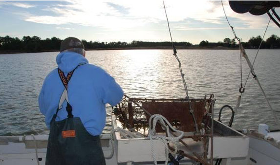
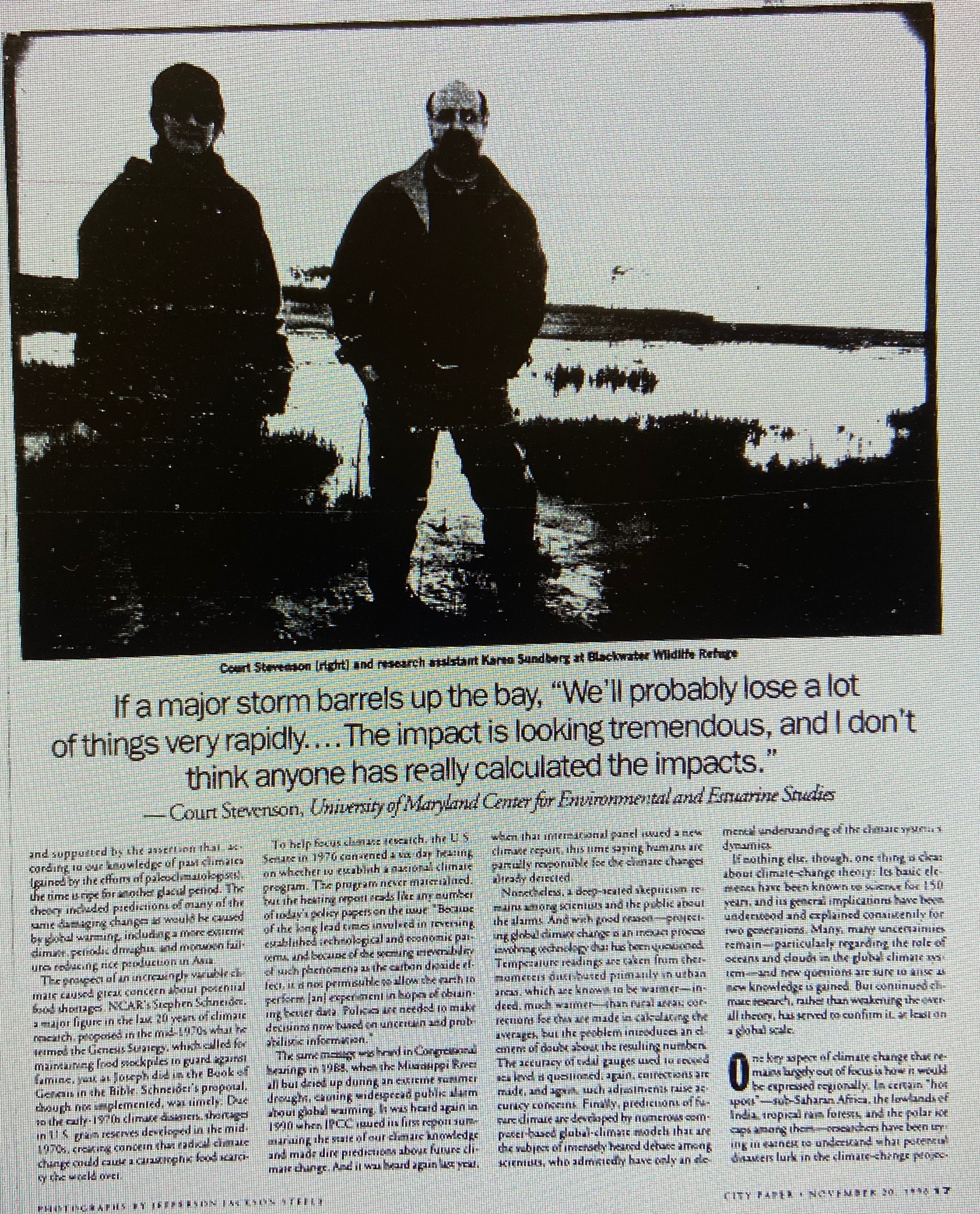
Court Stevenson, a plant ecologist with the University of Maryland Center for Environmental and Estuarine Studies, says the bay’s waters are rising between two and five millimeters per year – faster than the global rate of sea-level rise of one to two millimeters per year. The consensus, he says, is that the rate of the rise in the bay’s waters started increasing around 1850. One indication of the rise, he points out, is that some of Baltimore City’s “early land grants are now under water.”

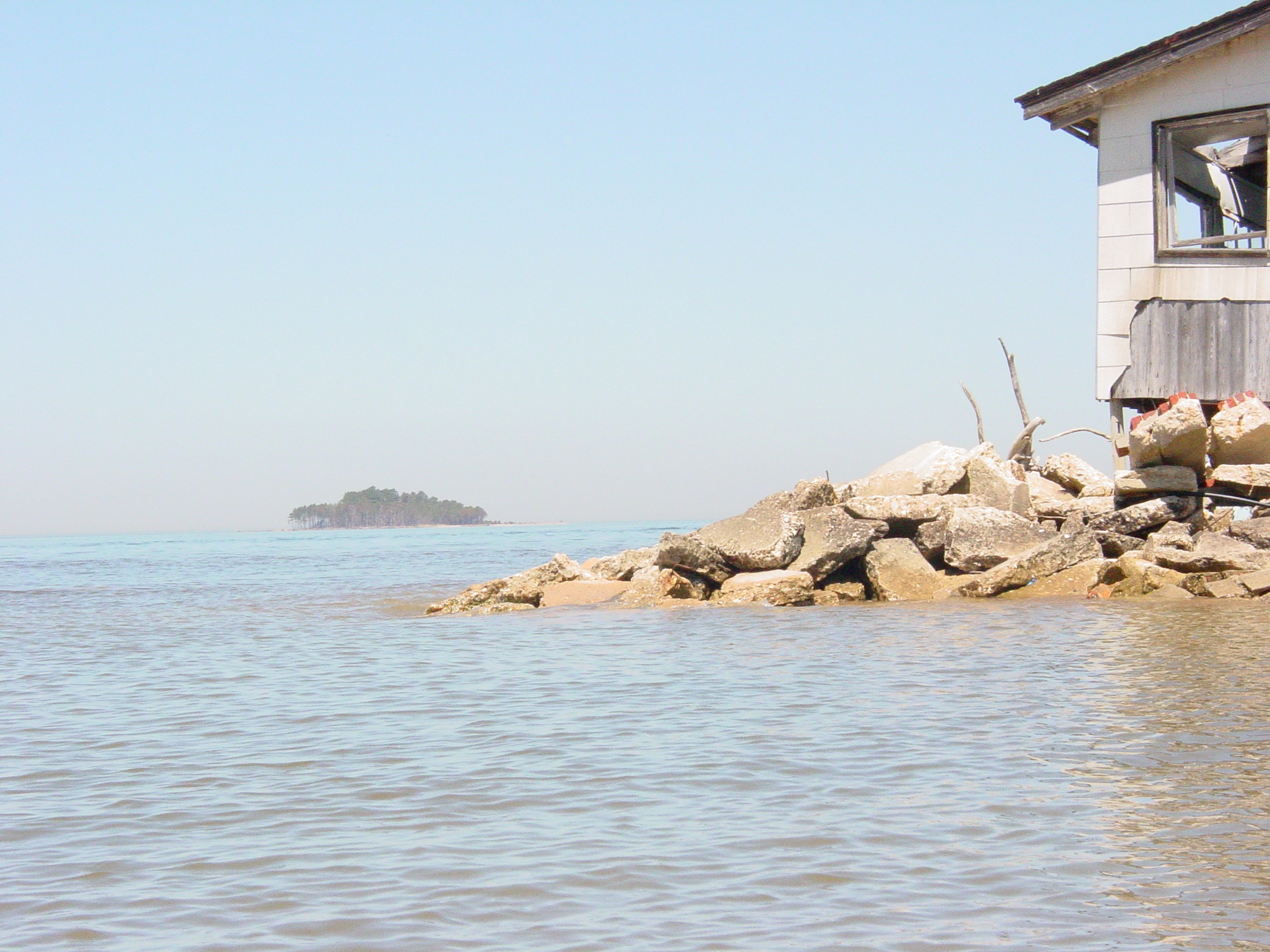
On the Eastern Shore, Stevenson says, “the largest single island in Maryland” has been created over the last 50 years in Dorchester County due to a combination of rising seas and subsiding land, dividing the county with tidal water. Another dramatic sea-level-related change has been in the Blackwater Wildlife Refuge, at least one-third of which has become submerged by bay water since the 1930s.

Given the existing effects of the bay’s rise, Stevenson says he is “astounded” and “deeply concerned” by the implications of predicted future increases. “If we see anything like two feet, we’ve got such flat land here [on the Eastern Shore], we’re going to see a lot of changes,” he says. “It is going to be significant in terms of the economy of the region.” Farmland, woods, and marshes, he says, will be lost from inundation or salt intrusion from the bay’s brackish waters. If a major storm barrels up the bay, Stevenson points out, “We’ll probably lose a lot of things very rapidly … The impact is looking tremendous, and I don’t think anyone has really calculated the impacts.”

One of the concerns about sea-level rise in the bay is whether it will wreak havoc with our energy systems. But Baltimore Gas and Electric (BGE), the region’s power supplier, is not currently concerned. “It is not something we have looked at,” BGE spokesperson Art Slusark says of the potential impacts of sea-level rise on its system, “nor has it been something that has been a factor” in planning for the utility’s future. Slusark says the company believes the bay’s rise will take so long that “our existing plants will be out of service before it happens.”

On the Western Shore, much of which is bordered by cliffs, there is “a lot of concern” that sea-level rise will cause dramatic shore erosion and “cliff retreat,” Stevenson says. “A lot of development is pretty close to the cliff – it is a big problem.” The only technology to prevent buildings from toppling over is the use of bulkheads along the shoreline to prevent wave action against the base of the cliffs. “The cheapest wooden bulkheads coast about $300 to $400 per linear foot, and there are many miles that would need protection,” Stevenson estimates. He calls cliff retreat “a time bomb waiting to happen.”

(Calvert Cliffs, where BGE’s nuclear reactors are located, is being significantly affected by cliff retreat, Stevenson says, but the nuclear facility is set back far enough from the cliffs to allay any immediate concern.)

Despite the potential for a dramatic rise of the bay, EPA’s Titus says public policy in Maryland does not yet officially recognize that it is happening (although officials are aware of the problem). For example, the state Critical Areas Act, designed to restrict shoreline development and preserve the bay’s coastal ecosystems, has been effective, but less and less land will be protected as the water continues to rise and shoreline is eaten away.

Meanwhile, Titus says, landowners try to prevent erosion of their waterfront property by installing bulkheads – a measure that as a practical matter denies the traditional right of public access to the shoreline up to the high-tide line. As the sea level rises and erosion occurs, he explains, the bay’s waters will lap up against the bulkheads, effectively privatizing the shoreline on which many rely for either income or recreation. He says 20 miles per year of the bay’s shoreline is already being lost to erosion, with the gravest losses on islands, some of which are inhabited and losing acreage quickly.

Titus says that state officials are planning to shore up inhabited islands with dredging spoils dug up to maintain shipping channels; the spoils currently are disposed of on the uninhabited Poplar Island. “It would be relatively expensive to ship spoils to these islands, but if we consider it worthwhile to spend hundreds of millions to have a football team, we may feel it worthwhile to preserve these islands, some of which have had people living on them for hundreds of years.

“Our policies depend on the assumption that the seas are not rising and the shoreline is not eroding,” Titus says. “But the science, on the other hand, says that sea-level rise is already happening and [there is] a high expectation that it will continue.”

IMG_3653

Despite the upward trend in global temperatures, no warming has been observed in the northeast United States, Titus says. The generally accepted explanation for this, he says, is “the sulfate cloud that hangs over the entire region.” The cloud is a result of industrial pollution and is made up of hydrogen-sulfate ions, which are highly reflective and cause solar radiation to bounce back up into the atmosphere rather than reach the planet’s surface. This masks the regional influence of the global-warming trend. (It also exacerbates urban pollution, Titus and others point out, because increased radiation encourages smog formation from sulfates, and smog has serious health effects.)

Nonetheless, on the local level – and, some say, even on the regional level – significant warming has been detected, but it is attributed to another phenomenon: the “urban heat-island effect.” In essence, this occurs wherever population is increasing and changes in land use are intensifying. More people means more industry, more automobiles, and other things that generate heat. It also means more buildings and roads and less vegetation; as a result, heat is retained by building materials during the day and is given off slowly at night, offsetting what would otherwise be cooling temperatures. Thus urban areas record higher temperatures than rural areas. Other climatic impacts from the urban heat island, experts say, include more precipitation, less snowfall, and more unstable air, which promotes tornadoes.

A clear demonstration of Baltimore’s urban heat island has been found by Helmut Landsberg of the University of Maryland Institute for Fluid Dynamics. Landsberg compared temperatures in the city with those of Woodstock, a rural town about 15 miles away, between 1904 and 1979, a period during which the metropolitan area’s population grew from about a half-million to two million. Woodstock’s annual mean temperatures remained unchanged, but Baltimore’s rose about 3.5 degrees – a very stark difference.

Arthur Viterito, a George Washington University geography professor who is one of the primary researchers of the urban-heat-island effect in this area, believes the Baltimore region’s heat island is pronounced and spreading – to the point of merging with other nearby heat islands. In a 1989 paper published in Climatic Change, Viterito demonstrated how Baltimore’s heat island combined with Washington, D.C.’s between 1950 and 1979, creating a continuous “heat corridor” along the axis between the two cities. Overall, he found, the Baltimore-Washington corridor has become three degrees warmer since 1950.

“Warming has continued in the Baltimore-Washington corridor,” Viterito says, and he asserts that it is spreading as rural expanses become developed all around the area, including along the main routes to Annapolis. As far as he knows. “No one has really looked at the merging of heat islands for different cities” outside of this area, but Viterito believes the phenomenon is spreading to other parts of the Eastern seaboard as well.

“You really do get permanent climate change on a regional scale now – not just local,” he says. “Within the next 50 years, we are going to see large-scale change [from merging heat islands] in the Boston-Richmond corridor … . A large part of global climate change is attributable to urban growth.”

IMG_3654

Other than demonstrations of the urban heat island, not much has been done to analyze Maryland’s climate to determine if it is changing. Viterito says he has “not seen anything done on the local climate since 1989,” when his paper came out. This leaves a big question mark, and an unfortunate one, because it appears from the available data on Maryland’s climate that extreme events are occurring more regularly.

For instance, tornadoes have been touching down more regularly in the Baltimore area – one hit North Avenue in November 1994.

Another troubling trend – one that is causing extensive damage to the Chesapeake Bay’s ecology, scientists say – is the near-record-high levels of fresh water running of into the bay in recent years. So far, 1996 has had the second-highest average daily flow on record, and 1993 and 1994 were significantly above-average years as well, according to figures maintained by the U.S. Geological Survey.

Such anomalies, as well as record monthly and annual temperature and precipitation averages, make lay people wonder what’s up with the weather. Answers aren’t forthcoming.

For instance, state climatologist Alan Robock, who is also a meteorology professor at University of Maryland, does not have a prepared study available for the public about Maryland’s climate.

“I don’t have all these records at my fingertips,” he explains. When asked if Maryland’s climate is thought to be growing more variable, what with reputed global climate change and the urban heat island effect, he responds, “It is normal for the weather to be variable and it is normal for the climate to change.”

On the Internet, monthly climate reports are available from the Northeast Regional Climate Center at Cornell University in Ithaca, New York. Records of extreme mean temperatures and extreme precipitation amounts include some interesting facts about Maryland’s recent climate: In 100 years of record-keeping, 16 records have been set for Maryland since 1981. 1990 was the hottest year on record. The summer of 1987 was the hottest summer on record, and record mean highs for four months – April, May, November, and December – were set during the period of 1984 to 1994. The only record for cold set recently was the 24.5-degree mean temperature in December 1989.

Regarding precipitation, four of the driest months and three of the wettest months in Maryland in the last 100 years occurred between 1983 and 1994. The driest spring occurred in 1986, with only 5.52 inches of precipitation; the wettest came in 1983, with 19.06 inches.

In the past two years alone, Maryland has had 17 monthly or seasonal temperature averages for precipitation readings that fall within the top 10 for those categories in 100 years of record-keeping.

Meanwhile, at Baltimore-Washington International Airport, where records have been kept since 1950, the record peak wind gusts for each of the 12 months of the year were recorded between 1985 and 1995. 1990 was the warmest year on record at BWI, 1991 was the second-warmest, and the next five warmest years occurred in the 1980s.

These climatic highs and lows occurring in recent clusters seem odd, but, as Robock explained, weather is always variable and climate is always changing. Without serious analysis, little can be made of these numbers other than that they are interesting and seem to indicate a lot of weather swings in recent years.

They are even more provocative because the records are occurring in conjunction with other extreme weather events, such as the all-time record snowfall total for 1996; the extended drought in 1995 that threatened Baltimore water supplies; large and growing numbers of reported tornadoes outside of the normal tornado season; and severe storms that dump extremely heavy rain in short periods of time. Most of these occurrences are anecdotal and might fall within the normal bounds of weather variability, but no scientist we contacted has studied or is aware of any studies showing whether they do or not.

IMG_3657

One of the more worrisome aspects of global climate change, one with possible consequences for this area, was studied recently by Jonathan Patz, a virologist at the Johns Hopkins University School of Hygiene and Public Health. The resulting article, published in the Journal of the American Medical Association in January, raises concerns that global climate change “can affect the introduction and dissemination of many serious infectious diseases.”

In particular, Patz and his coauthors note that climate-sensitive mosquito-borne diseases (e.g., malaria and dengue fever) and waterborne infections and toxin-related illnesses (e.g., cholera and shellfish poisoning) may become more widespread in a warmer climate, especially if human populations become more susceptible due to other climate-related impacts.

Patz summarized his research in a November 13th presentation at the Hopkins School of Hygiene and Public Health. He pointed out that worldwide, 11 climate-related disease outbreaks have already occurred in the 1990s.

Mosquito-borne diseases, he says, are likely to cause epidemics in warmer climates because the insects tend to be smaller and therefore need to bite more times in order to reproduce. Each bite increases the likelihood of disease transmission. This change may cause widespread fatal sickness, particularly in conjunction with other factors, such as the spread of the disease-carrying mosquitos into populations that have not developed immunity to the diseases. Also, such parasites have faster incubation periods in higher temperatures, which is “very important in terms of epidemic spread,” Patz said.

Patz is continuing his research into the disease-related impacts of global climate change and is starting to look into the potential of such problems – possibly even the spread of traditionally subtropical afflictions – in the mid-Atlantic region, including Maryland and the Chesapeake Bay. In particular, he says he will explore the prospects of outbreaks of cryptosporidium, which causes extreme and sometimes fatal diarrhea. He’s concerned that more severe storms and flooding may increase the likelihood of outbreaks in this region – as occurred in Milwaukee, Wisconsin, last year – because the waterborne disease is resistant to chlorination and can get by filtration systems. He stresses, however, that the research is only just starting and no conclusions have yet been drawn about risks in this area.

Another JHU researcher, Stan Becker, who studies population dynamics, is concerned about the health implications of global climate change in light of the tremendous population increase. “We are in a unique time in the history of this planet in regard to human population growth,” he explained at the November 13th Hopkins symposium. Currently there are approximately 5.7 billion people on Earth, and the number is expected to rise to somewhere between 11.3 billion and 19.2 billion by 2100.

Such a doubling or tripling of Earth’s population is bound to have an impact on the rate of global climate change – and if such rapid change occurs, the health stresses on the human population could be dire.

IMG_3658

So what is to be done? Do we stop driving, stop heating and cooling our homes and offices, stop having kids? Obviously, in our democratic society such behavioral changes would have to be voluntary – and such widespread change in habits is difficult to achieve, especially since most people haven’t considered the problem enough to understand it.

In 1994, the academic journal Risk Analysis published a survey of people’s knowledge of global climate change, and the results were enlightening: Folks, even well-educated folks, were woefully ignorant of the issue’s basic elements.

“Laypeople display a variety of misunderstandings and confusions about the causes and mechanisms of climate change,” the authors concluded. “Both the United States and the rest of the world are currently considering policy responses to the issue of climate change which would entail costs and expenditures amounting to trillions of dollars. U.S. society cannot have intelligent democratic debate on these choices unless people are better informed.”

At this point, probably the best step we as average citizens can take to deal with global climate change is to try to understand it. Maybe then we will grow to care about it more. As GWU’s Viterito points out, the “last big hurrah” in terms of public concern about global climate change was in 1990, when the world was especially tuned in to environmental problems. Since then, “everybody said they’re not interested anymore,” Viterito says, particularly because doomsday scenarios are no fun to contemplate.

“The Earth has been coming to an end since about 4,000 B.C.,” Viterito remarks, tongue in cheek, “so people tend to pooh-pooh this. But as the economy gets impacted, then people will start to pay attention again.”

What is needed to get our dander up now about global climate change? Viterito says it will take a climate-related disaster close to home.

“What you need is a humongous drought to hit the Northeast,” he says. “I’ll guarantee we’’ll talk about global warming again.”

Law of the Land: Maryland General Assembly works to restore weakened Critical Areas Act

By Van Smith

Published in City Paper, March 31, 2004

Shortly after Tropical Storm Isabel’s floodwaters hit the Chesapeake Bay shoreline last fall, carrying away chunks of waterfront land and destroying vast sums of bay-side investments, the Maryland Court of Appeals relaxed key provisions of a 20-year-old law restricting development within 1,000 feet of the water (“Time and Tide,” Oct. 22). Backers of the Critical Areas Act of 1984 assaulted the court’s opinion and argued that the law had slowed the pace of coastal construction for nearly a generation, and thus, by constraining new development where storms exact the heaviest tolls, had prevented further losses from Isabel. But the judges’ blow to the law, coming from the state’s highest court, was final. The job of straightening its spine now falls to members of the Maryland General Assembly, who are now attempting to trump the court’s move with legislation to restore the law to its original ecologically protective intent.

The Critical Areas Act, which bans new construction within a 100-foot buffer zone closest to bay waters and curtails it in specified areas within a 1,000-foot strip, is overseen by the state Critical Areas Commission for the Chesapeake and Atlantic Coastal Bays. The commission’s chairman, former Republican state Sen. Martin Madden, was sworn in less than a year ago and immediately alerted lawmakers of his hope to firm up the act’s enforcement provisions. Then came Lewis v. Department of Natural Resources, a case before the high court in which Edwin Lewis, an apparel-industry executive, belatedly sought permission to build a hunting lodge and cabins on a tidewater hummock he owns in Wicomico County. By the time Lewis had applied in 2000 for a county variance to build on his site, which is in the critical-areas buffer zone, construction had already started.

The seven-member court’s 4-3 decision relieved Lewis, and therefore other landowners in the critical areas, of the burden to prove that their proposed building projects won’t harm the bay. Instead, local governments now have to show that such projects would harm the bay. That’s a tall order for governments to fill, say Madden and others who criticized the court ruling. Asking cash-strapped counties to prove the harm caused by each proposed project in the critical areas, Madden says, would effectively undermine the law’s intended goal of protecting the shoreline from damaging development. To make matters worse, the decision condoned Lewis’ course of action: build first, seek permission later, then claim the remedy–the removal of illegally built structures–is an undue hardship.

“The ruling turned everything on its ear,” says Dru Schmidt-Perkins, executive director of the 1,000 Friends of Maryland, a nonprofit coalition that advocates environmentally sound growth. “Twenty years ago, when the law passed, we said, ‘We all agreed that we’re going to protect this fragile shoreline,’ but now we have to come back and re-establish the intent of the law. I find that extraordinary.”

In the decision’s aftermath, Madden, like the many homeowners repairing post-Isabel wreckage, set about patching up the court’s blows to the Critical Areas Act. He has been working his persuasive magic on his former colleagues in the state legislature, and his efforts appear to be paying off: The legislation, introduced this session, is moving through the General Assembly process at a brisk pace with little controversy or fanfare.

“The main bill basically brings us back to where we were prior to Lewis,” Madden says. It clarifies the law’s overall intent to protect the bay and plugs the holes shot through the law by the Lewis decision. It also increases penalties–from the existing maximum of $500, to a proposed $10,000–for violations. And it gives local governments the option of asking the state Critical Areas Commission to handle tough enforcement cases. The measure was supported by a broad array of interests–everyone from realtors and builders to the Chesapeake Bay Foundation and the Maryland Association of Counties–and passed, 41-6, in the Senate on March 22. The House will consider the bill after a hearing scheduled for April 2.

“It was agreed by everyone that we needed to go back” to the law’s pre-Lewis strength, says lobbyist Bill Castelli, of the Maryland Association of Realtors. “[But] everybody needed to get comfortable that the bill wouldn’t go beyond that.”

A comfortable consensus was reached, Castelli adds, after a few, minor clarifying amendments were added. Still, he points out a cautionary note about future litigation over a restored Critical Areas Act: “You just can’t predict what will and won’t get challenged in court.”

Time and Tide: Will the erosion of Maryland’s Critical Areas Act mean even bigger trouble when the next Isabel comes along?

By Van Smith

Published in City Paper, Oct. 22, 2003

Tropical Storm Isabel’s short visit exacted a pricey tribute on the Baltimore region’s shoreline. Thousands of homes were damaged and hundreds destroyed in Baltimore and Anne Arundel counties. Well water in many low-lying communities remains contaminated from the polluted floodwaters. Piers, boats, and boat-lifts were battered, broken, or carried away, while sea walls failed in some places, allowing Isabel to scour away chunks of earth from people’s properties. Bethlehem Steel’s Sparrows Point facility lost its multimillion-dollar power plant and had to close down production for six days. An Anne Arundel sewage-treatment plant also lost power, sending a hefty dose of untreated waste into Cox Creek near the city line. Baltimore City’s tourist-drawing waterfront choked on inventory losses, building damage, and missed business from Isabel’s historic tidal flood, which here and there breached the 100-year flood line. In all of Maryland, estimates of total losses from Isabel are in the hundreds of millions of dollars and climbing.

Given Isabel’s high cost and human suffering, it seems almost quaint to survey her effects on Baltimore County’s North Point State Park, a 1,300-acre tract of marsh, woodlands, fields, and bay-side frontage on the Dundalk peninsula between the Patapsco and Back rivers. But Steve Takos Sr., at 80 and after five surgeries in the past eight months, has good reason to visit on this sunny October afternoon. He first came here in 1937 as a duckpin-setter for a nickel a game, and later took tickets for amusement rides. That’s when it was Bay Shore Park, a resort on a trolley line that drew throngs from around the region to play on the water. One way or another, Takos has been working here ever since. When Beth Steel owned the property from 1946 to 1987, he served as a guide for Sparrows Point executives on lunch-hour hunting and fishing trips. Today, he’s a volunteer park ranger. His long past with the property now compels him to see how it fared in the flood.

“Holy Moses! I’ve never seen it this bad,” Takos exclaims as he stands at the foot of Ferry Grove Pier, where a cluster of waterfront buildings once sat, receiving visitors and trade from the Eastern Shore. Isabel tossed around the scattered remnants of the long-gone structures like so many grains of sand, creating high dunes of rock, brick, and Belgian block stretching back into the woods. Nestled among the mounds are hefty chunks from the shattered sea wall and pier, a section of which collapsed in a jumbled mass of cement and twisted rebar. “Thousand-pound boulders were just picked up and thrown” by the wind-driven waves, Takos marvels, adding that “this may have been worse than the storm of 1933,” which tore down the trolley line’s trestle bridge over nearby Shallow Creek.

Takos has already checked out the pounding the 1,000-foot-long fishing pier took (it’s closed indefinitely) and how storm-driven flotsam knocked the support posts of the restored trolley house out of whack. But he’s mystified by what he finds further up the park’s shoreline. Large trees toppled over a retreating bluff onto a newly expanded beach, where roughly 30 yards of high ground fell into the bay. A butte of sandy earth topped with grass and stones, eight feet high and five feet in diameter, was left standing like a sentry on the gouged-out shore. At its foot, a segment of old “corduroy road” was excavated by the bay’s storm-churned waters. Constructed of large timbers set side by side, the road served mule-drawn carts bringing building materials for the Bay Shore trolley line a century ago but has been buried for decades. The sudden reappearance of the corduroy road pleases Takos: “That’s one good thing [Isabel] did. I always said the tracks ran right through here, and there they are.”

He points to where a drowned section of Bay Shore’s sea wall pokes up through the tide a hundred or so yards offshore. Once a stout, six-mile-long barrier, he explains, the wall has since become an increasingly fragmented line of broken cement and rocks that here descends into open water, forming a shallow bay behind it. “There was all high land up to that sea wall,” he remarks while standing on the edge of the bluff. “Lost all of it in 60 years.” Takos has been around over the decades to watch firsthand as the bay swallowed up the land here. With Isabel’s help, it took another big bite.

The day after Takos’ visit to the park, on Oct. 10, a storm of another sort came down from the state’s highest court and took a bite out of the law designed to protect the bay’s shoreline. The 1984 Critical Areas Act governs development in almost 700,000 acres within a 1,000-foot strip around the Chesapeake Bay’s Maryland shoreline and virtually bans new construction inside a 100-foot buffer zone closest to the water–the so-called “critical areas” where new construction is reviewed, guided, and in some cases stopped altogether. In its final word on the case of Lewis vs. Department of Natural Resources, the seven-member Court of Appeals declined to reconsider a July decision that the three dissenting judges say hobbled the act. Unless the state legislature repairs the damage to the law–and it is expected to try in the coming session that starts in January–planning boards in the 16 bay-side counties and 45 municipalities affected by it can expect to see property owners try to exploit the Court of Appeals decision with new building proposals. Already, “it’s seeping into arguments that we are hearing on the local levels,” says Martin Madden, a former Republican state senator from Howard County who in late spring was named chair of the Critical Areas Commission charged with implementing the law.

North Point State Park’s eroding waterfront has a lesson to teach about the Critical Areas Act: Government may try to legislate development along the shore front, but nature bats last. Scientists expect the coming decades to bring more frequent and stronger storms for the Mid-Atlantic, as the bay rises in step with global sea-level rises. If the experts are right, North Point’s history serves as a graphic harbinger of what ultimately can happen to shoreline development: buildings and piers smashed by the sea, once solid ground eaten away and reclaimed by flooding and erosion. By paving the way for more bay-side development, the Appeals Court’s decision on Lewis virtually assures that more property owners will face those inexorable natural forces in the future, likely losing homes, improvements, and raw acreage in the bargain.

“The [Critical Areas] Act says it’s good to move people out of that buffer area for the bay’s sake,” says J. Court Stevenson, an ecologist and sea-level rise expert at the University of Maryland Center for Environmental Sciences near Cambridge. The law, he points out, theoretically gives the Chesapeake more of a chance to rebound from its various environmental ills by discouraging human activity directly on its shoreline. But, he adds, rising seas and violent storms “show that it’s also good to move people out of the buffer for people’s sake.”

Crafting a passable critical-areas bill back in 1984 meant pulling a few of its teeth. Thousands of undeveloped parcels were legally partitioned into buildable lots before the law took effect and grandfathered in, Madden and the Critical Areas Commission’s executive director, Ren Serey, explain in an interview, but there is no way to estimate how many or their combined acreage. And the law designates 5 percent of land as a “resource conservation area,” subject to a low development density of one dwelling per 20 acres, to be reclassified by local planning boards in a “growth allocation” process to allow more intense uses. The law’s untapped–and largely unknown–potential for future shoreline development is enormous. The only way to slow that growth is for legislators to change the law.

The law’s built-in weaknesses are the source of much browbeating from people who expected it to have done more to rein in waterfront development as its second decade begins. State Del. Joan Cadden, an Anne Arundel County Democrat and member of the General Assembly’s joint Committee on Chesapeake Bay Critical Areas, voiced this sentiment with great frustration at a July 7 committee hearing: “How do we allow them to do these things? I thought that’s what we were all about, making sure that kind of development didn’t happen anymore. I thought that is what we were here for.”

“You all need to get some teeth,” chided Calvert County Democrat Del. George Owings III at the hearing. He told the story of how novelist Tom Clancy cleared a wide swath of trees down to the waterfront of his Calvert County property, “and got a tiny little fine.” “Just pay the fine and take the view, that’s what’s happening here,” Owings said.

Madden had an answer to that. “Enforcement is spotty, inconsistent, and deteriorating,” he told the joint committee. “It’s easier [for property owners] to pay a $500 fine and freely develop the property.” His solution: “We will probably look for penalties in the area of $10,000 instead of $500. We will also work to allow the local governments to refer to the commission on a voluntary basis a violation that they feel maybe they just don’t have the ability to handle because they are overwhelmed with other issues.” Madden also pointed out that the commission has no powers to strengthen its rules or enforcement powers: “The legislature has to do that.”

Madden didn’t have an answer to a big-picture gripe from the committee’s co-chair, state Sen. Roy Dyson, a Southern Maryland Democrat: “The truth of the matter is, what has happened with the bay cleanup is that it has stalled. Million-dollar homeowners support the bay cleanup without understanding their own contributions to the problem.”

The contributions Dyson referred to are actually codified as “findings” in the critical-areas act, making it a matter of law in Maryland that human activities like building and tree-clearing and their cumulative effects harm the bay, while minimizing such activity aids in the bay’s restoration. But Dyson’s allegation of hypocrisy among wealthy waterfront property owners underscores one of the law’s most noticeable impacts: rising property values in the critical areas.

The ink had hardly dried from then-Gov. Harry Hughes’ pen before the land rush started on properties within its yet-to-be-drawn border. Prices started going up immediately, and they’ve never stopped. As a result, wealthier people have been supplanting middle-class waterfront owners. “McMansions are springing up where bungalows used to be,” an Anne Arundel County planner puts it. With the monied property owners come lawyers. From 1984 until 1999, the Critical Areas Act went largely unhindered by adverse court decisions. Then, before the Lewis decision came down, three cases hit the Court of Appeals in succession, and the unanimous rulings of the court knocked open loopholes for more development. As a result, the General Assembly in 2002 revisited and strengthened the act.

Enter Edwin Lewis and his lawyer, Raymond Smethurst Jr. of Salisbury. Working for apparel-industry giants Tommy Hilfiger and Polo Ralph Lauren had been good to Lewis, an avid hunter who’s long enjoyed the Eastern Shore at his waterfront estate. In 1999 he added to his idyllic holdings, buying up nearly 300 acres of Wicomico County marshland. In the middle of it is a five-acre hummock, a rise in the marsh with trees growing on it, where in early 2000 Lewis proceeded to build a hunting lodge, four cabins, and a shed–all of it without permits and all of it inside the 100-foot critical area buffer zone.

Construction was almost over before anyone noticed. Once the authorities caught up with Lewis, Smethurst stepped in, bringing his experience working for those accused on the Eastern Shore of breaking land-use laws. Lewis didn’t purposefully break the critical-area rules, Smethurst explained. Then Lewis sought a zoning variance to allow the lodge and one cabin to remain in the buffer area. When it was denied, Lewis had Smethurst appeal it all the way up to the top–and won, because the court ruled there wasn’t sufficient evidence to show the project harmed the environment.

To Ren Serey, who’s been the executive director of the Critical Areas Commission since 1995, the Lewis ruling was a serious blow both to the commission and to zoning laws generally in Maryland. First off, he explains, it shifted the burden of proof from the property owner to the government in assessing the potential harm a project may cause. Thus, instead of requiring property owners to show local planning boards why their projects would not cause harm, it’s now up to the government to show why the project would cause harm. “That’s new,” says Serey, “and in our viewpoint, a significant burden on local government, both in and outside the critical areas, because now they, not the applicant, have to prove the question of harm.”

The ruling also flouted “the self-imposed hardship rule,” Serey argues. Now, the fact that something has already been built without permits, and that the remedy–removing the structure–would be a “self-imposed hardship,” can be used to argue that it should be allowed to stay. “The court even said,” Serey continues, “that the fact that Mr. Lewis actually started constructing these cabins benefited everybody because he could use their construction to prove that he wasn’t causing harm.” Finally, Serey contends that the court overlooked the findings of the legislature about the cumulative human impacts that harm the bay.

Appeals Court Judge Alan Wilner minced no words in his dissenting opinion on the Lewis case, in which he was joined by two other judges. “This was not just a disagreement over a point of law,” he writes of the 4-3 ruling. “In my view . . . the majority Opinion was deliberately designed, and, unless the General Assembly acts swiftly and decisively, may be effective, not only to dismantle the critical areas program but to seriously weaken fundamental zoning and land use controls generally.” Wilner further wrote that the decision was as “an invitation to the very kind of lawless behavior that occurred in this case–ignore the law, destroy the habitat and build where the law does not permit, do it all in secret, and then claim hardship.”

The majority opinion on Lewis plays down the case’s broader impact. But within days after the Lewis decision came down on July 31, Madden recalls, “we had a hearing in Anne Arundel County where a local zoning examiner had a complaint by some neighbors that a person was building their house much larger than had previously existed within the sensitive buffer area. And it was pointed out that this person had already built it, so to tear it down would be a big inconvenience, but it is a self-imposed hardship, so be it. And the hearing examiner made the comment that, ‘Well, until three days ago, I would have thought that was the case.’ I suspect we’re going to hear a lot more of that.”

The build-first, ask-questions-later mentality is alive and well along the bay. Serey doesn’t know the total number of violations found annually, but says construction without permits is a regular occurrence and that they are usually discovered after a neighbor complains. If the Lewis ruling ends up encouraging lawlessness, as Judge Wilner predicts, and if the fines imposed for breaking the act aren’t increased, the mentality is likely to bloom, resulting in even greater investment in bay-side improvements. To Court Stevenson, the University of Maryland sea-level expert, the whole trend is ass-backward.

Stevenson is standing on what he thinks may be one of the highest points in Dorchester County, the waterside lawn of the Horn Point Laboratory near Cambridge. At the bottom of the grassy slope heading down to the banks of the Choptank River is a sea wall, with a tumble of large rocks behind it. Isabel’s flood tide breached both the wall and the rocks, allowing the bay to scour out large patches of earth and grass along the steep riverbank. Stevenson has worked here since 1972 and says he’s never seen a storm do this.

“We really can’t say what will happen with these storms,” he muses, “so that’s why talking about futures is dicey.” But he does know that the seas are warming measurably on on the Atlantic, which is fueling more hurricanes to hit the Mid-Atlantic coast. “We’re now prone to storm activity that 100 years ago we wouldn’t have seen, with hurricanes just lining up from Africa,” he says. “Isabel did this, and it wasn’t even technically a hurricane anymore. Get a category 2 or 3 hurricane in here, and really get a surge in here–instead of seven feet, say, get eight feet–and there’s going to be wholesale damage.”

So the damage from Isabel, Stevenson hopes, will be read as a warning sign to keep new development out of harm’s way. And, in planning circles, that’s exactly how Isabel was interpreted. “There was a large difference between what was forecast in terms of flooding and what ultimately came to pass,” Baltimore City planner Peter Conrad explains. “In some areas of the city and elsewhere, the water came above the 100-year tidal flood line on the maps used to determine the flood zone for insurance and permitting purposes.”

Ultimately, after a lengthy public process that has yet to begin, new maps could move that line farther inland. “We may add another half-foot or foot of elevation on all new construction” in the city’s flood-prone areas in order to reduce potential storm damage in the future. This “will take several years,” Conrad says, but its impact on shoreline development could be significant. “From the city’s perspective,” he concludes, “we want to encourage development along our tidal area, but we need for it to be safe for 50 or 100 years.”

Stevenson’s research has for years now been focused on trying to help planners like Conrad figure out what more storms and flooding could mean in the context of rising sea levels. The observed rise at the Baltimore City tide gauge is 13 inches from 1903 to 2003, but Stevenson says “most of us believe that we’re seeing an acceleration, and that the rise could be two or even three feet in the next century. Unless we get the greenhouse-gas problem under control–because that’s what’s really driving the rise, the warming atmosphere due to greenhouse gases–it’s just going to get harder and harder and harder in low-lying areas.

“But you’ve got to watch yourself when talking about this stuff,” he jokes. “If you start worrying about this too much, people start to wonder about your sanity.”

Stevenson reaches down and uses his index finger to draw in the sand a profile of a house, the shore, and the sea. “Here’s what Jim Titus says we should do,” he begins. Titus is the federal Environmental Protection Agency’s top sea-level expert, and has long been involved with how the issue pertains to the Chesapeake. “He says let the tide come up, move the houses back, and then buy shore front easements to protect the land in between. But it’s not clear where the money for all those easements will come from. I think it’s more likely that people harden the shoreline to keep the sea-level rise out, with sea walls or bulkheads. And that causes all sorts of ecological problems.”

“There are choices that sea-level rise confronts us with,” Jim Titus explained during a seminar at a national coastal-zone management conference held at the Baltimore Convention Center in mid-July. “But they boil down to this question: Are we going to hold back the sea, or are we going to let our wetlands migrate inland?

“In Maryland, property owners can hold back the sea where they choose to hold back the sea,” he continued. “The general policy seems to be to encourage armoring [the shoreline] and discourage coastal development.” But, he pointed out, conservation easements in Maryland–legal arrangements that, for a price, take away development rights from property owners–don’t affect the right to armor the shoreline, so there would have to be a change in the law to use easements to allow inundated wetlands to re-establish themselves further inland. “We simply haven’t yet completely decided what we intend to do,” he concluded.

Kerry Kehoe, who recently came to the Maryland Department of Natural Resources to direct its coastal program, shares Titus’ and Stevenson’s concerns about how to handle sea-level rise. But he also foresees people’s reactions when they get warning signs that the seas are coming too close to home. “Storm surges and flooding will send a message to get out of there,” he predicted at the coastal conference. “The physical impacts will start to make it obvious–erosion, flooding, higher water tables causing contaminated drinking-water supplies.” Along the undeveloped Chesapeake shoreline, Kehoe points out that “there are still plenty of potential wetland-migration areas” where bulkheads have not been constructed. “The bad news is those very same areas are under substantial development pressure–that’s where people want to live.”

That’s also where the Critical Areas Act was intended to limit growth and development. But, in Stevenson’s estimation, the law’s constraints have had limited–and sometimes dubious–effects. “I think it’s had an impact,” he says with a note of irony. “I’m not so sure it’s all positive, though.” The first thing that comes to mind is the land rush back when the law first passed, which created all those untold thousands of grandfathered tracts. Then there’s the issue of wealth and class: Rising land values in the critical areas mean the waterfront is less and less available to the working-class people who have traditionally lived along the bay. And finally, he points out–and Serey and Madden confirm this–the fact that the 1,000-foot critical-area line doesn’t move inland with sea-level rise, but remains based on wetlands maps drawn in 1972. Although the 100-foot buffer line does shift with rising sea-level, property owners are entitled to bulkhead back to the 1972 tide line.

“The act largely ignores the unavoidable issue of sea-level rise,” Stevenson contends, “and ultimately that’s going to reduce the amount of land subject to it.”

“In the long run,” Stevenson says of the Critical Areas Act, “it had a lot of good ideas, good concepts” about what harms the bay and the human role in that harm. But he says it “hasn’t really delivered” the goods in terms of lessening human impacts. “I don’t know exactly, but it seems to me it hasn’t stopped much development, even in the buffer zone.” He’s waiting for local governments to use up their growth allocations–something that Madden says is years away–because then, presumably, much of the new construction on vacant shoreline will cease. “When the growth allocation really runs out, that’s when I’ll be happy,” he says

Madden, though, defends the act’s impacts. Despite the grandfathering and the growth allocations, it still has significant muscle, he says, and the legislature is always free to strengthen however it sees fit. “We’re going to look for Senator Dyson and Delegate [Barbara] Frush to take the lead on that, based on our recommendations.” Dyson and Frush, the oversight committee’s co-chairs, did not return phone calls about possible critical-areas legislation to be introduced in the coming session.

In the meantime, Madden explains, about 2,000 projects go through critical-areas review each year, a process that sends the commission’s staff through a proposal’s details with a fine-tooth comb, looking to make sure the design and construction minimizes harm to the bay. And that process, along with the more stringent requirements in the buffer zone, has made for more sensible, if not less, development.

“It is going to be interesting,” Madden says, “to compare the damage from Isabel to affected properties that were built after the critical area law took effect, as opposed to properties that existed prior to that. Because I think you’ll find that the development that took place after the critical area law, where we protected the buffer as much as possible while still accommodating growth, had much less damage than pre-existing properties that were built within the buffer right up to the shore. There are good environmental reasons to have a buffer . . . but I think Isabel shows that there are good, sound economical reasons to have a buffer also.”

The question is, how protected is that buffer after the Lewis ruling? And if it is in fact gutted, will expensive, newly developed properties soon face the fate of the thousands of homes hit hard by Isabel–and, in the long run, the fate of Bay Shore Park. Sea-level rise and hurricanes will ultimately rule the shape and scope of future shoreline development, but for now, repeats Madden, shoring up the Critical Areas Act is “up to the legislature.”

Working Skiffs: Overlooked as a kayaking destination, Baltimore and the Bay make for excellent native paddling

By Van Smith

Published in City Paper, May 22, 2002

When it comes to sea kayaking, Monterey has nothing on Baltimore. A tourism industry focused on the waterfront? Check. Tidal wetlands to explore? Hey, we live on the nation’s largest estuary, the Chesapeake Bay, with thousands of miles of tidal shoreline. About the only sea-kayaking attraction we don’t have that the Northern California coast does is sea otters–and sea kayaks.

In Monterey, throngs lounging in the hotels, bars, and cafés stretched along the water’s edge survey the Pacific coast as flotillas of kayaks bob by in the swell, many of them en route to Elkhorn Slough, a small estuary whose tidal wetlands are the area’s paddling gem. In Baltimore, the Inner Harbor promenade attracts constant crowds to the waterfront, yet rarely do they see a kayak gunk-holing around the harbor basin. And except for a few select areas, sea kayaks–portable, sleek paddle craft with closed decks–remain maritime oddities along Chesapeake estuarine shores.

The sparse popularity of a sport to which this area is so perfectly suited is inexplicable to Joel Beckwith, manager of the sports-equipment company Springriver Corp.’s local store. Since 2000, Beckwith, at work on a paddling guide to the Chesapeake, has been making a sea-kayak study of the Delmarva Peninsula, starting in Havre de Grace and heading south to Cape Charles, Va., then north on the Atlantic Ocean side to Lewes, Del. Along the way, he’s seen “very, very, very few kayaks. A lot of places we didn’t see anybody other than work boats. It’s amazing.”

Maybe it’s the water. Around Baltimore, it’s downright nasty. Trash, runoff, and the city’s now-famous sewage-system problems (requiring $900 million in repairs over the next 14 years) taint much of the Patapsco, as does industrial pollution, much of it embedded in the river’s sediments. And the Chesapeake as a whole isn’t exactly pristine, what with Pfiesteria and mycobacteriosis eating away at the fish and the declining numbers of crabs and oysters. But that’s the nice thing about a sea kayak–you get in the water, but you don’t have to get wet (except maybe a few splashes here and there, or in the unlikely event of a capsize).

Or maybe it’s Baltimore’s tendency to resist new things. Although kayaks have been around for eons–ancient Eskimo vessels inspired today’s varied designs–the market for kayaks in the United States has been booming. Just as Baltimore never really caught on to the dot-com revolution before it ended, the kayak craze has been passing us by.

No big deal. For those who do kayak in Baltimore and the bay–including yours truly–the local lack of interest leaves more territory to explore without fellow paddlers intruding on our adventures. Whether it’s barhopping from Locust Point to Fells Point, nosing up dark tunnels under the city’s streets, surfing with the breeze off Fort McHenry, or poking around wetlands that used to be shipping terminals, Baltimore offers kayaking possibilities that are nothing if not varied. And if cityscapes don’t float your boat, a short drive takes you and your vessel to the natural environs off Baltimore and Anne Arundel counties. Cross the Bay Bridge and the paddling options are virtually limitless.

In the city proper, there are precious few decent put-in spots: the low dock next to the Korean War Memorial in Canton, Ferry Bar Park in Port Covington, and the boat ramp next to Harbor Hospital in Cherry Hill. Further down the Patapsco, Fort Armistead and Fort Smallwood–both city-owned parks with boat ramps–provide additional water access. If you don’t own your own boat, city dwellers can join the Canton Kayak Club (www.cantonkayakclub.com) and use its kayaks and equipment, which are kept on docks at Tide Point in Locust Point and Tindeco Wharf in Canton.

For kayaking on somewhat cleaner waters, head out to one of three nearby state parks: Sandy Point (by the Bay Bridge near Annapolis), Rocky Point (where the Back River enters the bay near Essex), and Gunpowder Falls’ Hammerman Area. The latter, at the end of Eastern Avenue near Chase, is also home to Ultimate Watersports (www.ultimatewatersports.com), which rents boats and helps new paddlers learn the ropes. Regular paddlers who use these parks can save on entrance fees by purchasing a yearly pass, which costs $60 and provides access to all Maryland state parks.

Perhaps the best way to enjoy the Eastern Shore by kayak is to plan your own trip. DeLorme’s Maryland Delaware Atlas & Gazetteer (www.delorme.com), which combines road-map information with topographic detail, can get you where you want to go. After locating your destination, pay a visit to the Maryland Geological Survey (either at 2300 St. Paul St. or at www.mgs.md.gov) and procure more detailed maps. The quantity of Eastern Shore territory that is navigable by sea kayak is astounding, especially between St. Michaels and Crisfield, where much of the coastline is untouched by development.

Despite the smallness of Baltimore’s community of sea kayakers, there are plenty of ways to get involved and to keep abreast of activities. Springriver Corp. (6434 Baltimore National Pike, Catonsville, [410] 788-3377) and REI (63 W. Aylesbury Road, Timonium, [410] 252-5920) both sell kayaks and boast knowledgeable staff who can help get you on the local waters. The Greater Baltimore Canoe Club (www.baltimorecanoeclub.org) serves as a gathering point for local paddlers and hosts outings. And the newly hatched SeaKayak Web site (www.seakayak.ws) gives in-depth information about kayaking on bay waters. (One of SeaKayak’s hosts, Stephen Rohrs, taught me to roll in a sea kayak–after many unsuccessful attempts.)

Still, Baltimore is no Monterey, no sea-kayaking mecca. And it’s not likely to become one. As Springriver’s Beckwith says, “I’ve been promoting the sport in the Baltimore area for 20 years and I’ll be damned if it’s made a bit of difference.” Even in a place as eccentric as Baltimore, a kayak remains an enigma on the water. And that’s fine with me.

Some Sewage Runs Through It: The Gwynns Falls Trail is dedicated, but parts of the Gwynns Falls are just plain dead

By Van Smith

Published in City Paper, June 5, 2002

“That’s raw sewage right there,” says Rob Johnson, a city sewer supervisor, as he points at the gray, turbid water running through a fetid Southwest Baltimore stream. It’s around 8 a.m. on May 29, and Johnson’s back at the same spot he’s been most every morning for well over a month – at a Yale Heights manhole next to an unnamed tributary of Maiden Choice Run, monitoring a periodic sewer leak until the city can diagnose and fix the problem.

The polluted stream winds through piles of trash and debris and mounds of slime-coated rocks and sediment, fouling the air around homes in Yale Heights and Irvington. Maiden Choice runs clear until it’s joined by this tributary. Downstream, as it tumbles across a historic stone dam in Loudon Park Cemetery – where neighbors say children swim and play in the water – Maiden Choice runs gray and smelly toward the Gwynns Falls and, ultimately, the Chesapeake Bay.

Later that day, the second of three segments of the Gwynns Falls Trail is dedicated in a ceremony filled with optimistic speeches and calls for volunteerism. The bike trail, a decade in the making and four miles long so far, eventually will grow to 14 miles, linking Leakin Park with the Inner Harbor and the Middle Branch of the Patapsco River.

“We’ve got the basis to make something really great here,” an earnest Mayor Martin O’Malley proclaims from the podium. “The health of our parks is a really good indicator of the health of the city.” He goes on to acknowledge that the Gwynns Falls still needs some help: “We need to fix it up, make it more accessible, make it cleaner.”

As the crowd of trail enthusiasts and environmentalists mills about, some talk about how the quality of the Gwynns Falls’ water is tied in with the success of the trail.

“Having a greenway and an ugly stream running through it is not a good idea,” says Ellen Smith, trail coordinator for the nonprofit Parks and People Foundation. “Water quality and trail quality are intertwined.” Opening the trail gets people near the water, she says, creating a greater awareness of the Gwynns Falls’ problems and, hopefully, generating the political will to take measures to solve them.

The U.S. Army Corps of Engineers is also planning to help out. In March , the Corps announced a proposal to conduct numerous sewer-rehabilitation projects in the Maiden Choice Run and Dead Run areas of the Gwynns Falls. The idea has yet to get approval from Army Corps brass, much less any funding, says Chris Spaur, a Corps ecologist. But the plans are ambitious.

For now, the will to improve the Gwynns Falls’ water quality is coming from the federal and state government – in a big way. On April 26, the city, after years of noncompliance with the federal Clean Water Act, agreed to start a massive overhaul of its sewer system. Systemwide, the upgrade will cost about $940 million over 14 years. For the Gwynns Falls watershed this year, the city has allocated nearly $15 million for projects to improve stream quality, including sewer repairs, a debris collector, a storm-water containment pond, and a flood dike.

“The way it is now,” says Spaur of the sewers in the area, “there are little leaks all over the place. The pipes are made of vitrified clay with joints every several feet. Most of them were laid in the 1920s and 1930s, in and around streambeds. After all these years, the joints are leaky and there are lots of cracks.” If realized, the work as currently planned would involve fixing nine miles of sewer pipe and nearly 300 manholes, plus wetland restoration and streambed stabilization.

While these big public-works projects get underway, the Gwynns Falls is under a microscope – literally. Scientists from a variety of disciplines have been concentrating their research on the Gwynns Falls as part of the Baltimore Ecosystem Study, a National Science Foundation investigation into how natural and human-made elements of the urban environment interact. As research continues, available information on the health – or ill health – of the Gwynns Falls will continue to grow.

Rob Johnson, the sewer supervisor, knows firsthand one of the Gwynns Falls’ major problems: chronically leaky sewers. This morning, standing near the Yale Heights manhole as he has for weeks, he can’t do anything but watch as raw sewage trickles into the stream. Someday soon, once he gets his electronic diagnostic device back from La Plata–where he says it’s on loan to help sort out sewer damage from the recent tornado–he’s going to locate this leak.

“And then,” he says confidently, “we’ll come in and fix the whole thing.”

Meanwhile, as work on Phase II of the Gwynns Falls Trail progresses, the city is returning to the already opened first portion of the trail – completed in 1999 – to conduct $150,000 in repairs.

“There’s been some erosion on the trail,” explains Gennady Schwartz, the city Department of Recreation and Parks’ capital-projects chief, “so we need to redo some of the work.”

Trail maintenance – like beach replenishment in Ocean City – is going to be an ongoing cost for the city. “That’s the price to pay, but I think we’re willing to do that,” Schwartz says. An attractive trail that is well-used, he says, “will bring people’s attention to the problems in the watershed.”

Raising a Stink: City Paper’s discovery of a recent sewer-leak spike along Greenspring Avenue highlights pollution’s persistence

By Van Smith

Published by City Paper, May 7, 2014

Raw sewage, which is supposed to be carried to treatment plants via underground pipes, overflowed 16 times since last summer along a five-block stretch of Greenspring Avenue between Cold Spring Lane and Northern Parkway in Baltimore, according to the city’s reporting of such incidents. In all, these overflows spewed at least 12,000 gallons of nutrient-laden effluent, to make its way through storm drains and streams downhill into the nearby Jones Falls, the Baltimore Harbor, and ultimately, the Chesapeake Bay, where it contributes to algal blooms and fish kills.

While this is a regular occurrence citywide – in March, the city reported 68 such overflows, leaking an estimated 10,000 gallons of sewage – until recently it hasn’t been along this stretch of Greenspring Avenue, where there had been only seven reported overflows between 2005 and 2012.

Surely, community leaders in the area would have noticed the sudden sewage surge. After all, since 2002 the city has been working diligently under the terms of a court-mandated consent decree resolving a Clean Water Act lawsuit brought against it by the U.S. Environmental Protection Agency (EPA) and the Maryland Department of the Environment (MDE) to plug up its chronically leaky sewer system – a $900 million project which has spurred repeated hikes and water-and-sewer rates.

Turns out, though, they hadn’t.

City Councilwoman Sharon Green Middleton (D-6th District), who lives in the affected neighborhood, said in an April 23 phone interview that “there has not been a complaint from my association” about sewage leaks, and notes that sewage leaks “are never the conversation of the meetings of the community associations” in the area.

“I checked to see if there have been any constituent complaints to my office about this from these neighborhoods,” she adds, “and there have been none whatsoever since I’ve been in office.”

The same day, in response to City Paper‘s inquiries about sewage leaks in the area, Chikwe Njoku, president of Coldspring Community Association, wrote in an email that “I am not aware of any issues as it relates to sewage overflowing along Greenspring Ave.,” adding that while he understands “the Jones Falls often does receive sewage,” it “doesn’t have any direct impact on the neighborhood since homes are well away from it.”

The next morning, while awaiting a response about the matter from Blue Water Baltimore (BWB), the city’s main water-quality advocacy group, a City Paper reporter hoofed around in the woods northeast of the intersection at Greenspring Avenue and Cold Spring Lane, flushing out deer and ducking briars in an effort to find evidence of sewage contamination.

Rather than what was expected – a chronic sewer leak in these woods, dubbed in 2008 by the Jones Falls Watershed Association (since subsumed by BWB) as one of the city’s “Filthy Five,” responsible for releasing an estimated 21,600 gallons of raw sewage each day – we found something else: the unmistakable stench of sewage where a storm-drain outlet empties into a stream, turning its water opaque and gray.

After taking photographs, the reporter discovered that the easiest access to this sewage-contaminated storm-drain outfall is through a broken fence from the playgrounds of KIPP Harmony Academy, a public-charter elementary school, though it also can be reached from the athletic fields of the nearby Waldorf School. There were no signs announcing that the stream may be fouled by sewage, which contains bacteria, parasites, and viruses that can cause a variety of illnesses.

Back at City Paper‘s office, BWB’s emailed response was waiting: “We were not aware of the recent uptick in sewer overflows in this section of the Jones Falls,” wrote David Flores, BWB’s Baltimore Harbor Waterkeeper.

“We had been monitoring a sewage-contaminated storm-water outfall located at the intersection of Greenspring Avenue and Cold Spring Lane for several years,” Flores continued, adding that the city’s Department of Public Works (DPW) “has since reported that the sewage leak at that location has been located and fixed.” Back in February 2012, Flores explained, BWB “investigated and reported [a sewer overflow] along Greenspring Avenue,” but the group “has since neither encountered nor received any citizen reports of sewer overflows at this location.”

Once City Paper emailed its photographs of apparently sewage-contaminated water coming out of the storm drain to foul the stream below KIPP Harmony Academy, BWB and DPW kicked into action, with each sending staff to investigate the matter.

While awaiting the results, BWB’s executive director, Halle Van der Gaag, commented that “this looks like a pretty big deal and I will be very interested in seeing it corrected and understand what has happened.”

Within hours, BWB’s water-quality manager, Alice Volpitta, had sampled the water, found it to have elevated indicators of sewage, and noted that “sewage fungus” was growing “in the culvert where the sewage is flowing.” The fungus, she explained, “is a collection of the bacterial cells found in the contaminated water, and it takes time for the ‘structure’ of the sewage fungus to form,” so its presence “is an indication that the problem has been on-going.”

First thing in the morning on April 25, DPW’s Joan White, a pollution-control analyst supervisor, emailed City Paper to explain that “my team found a choked sanitary line at 2917 Thorndale Ave. causing sewage to infiltrate the storm-drain behind KIPP Academy yesterday afternoon,” adding that the problem had been fixed.

Meanwhile, City Paper also asked EPA and MDE – the overseers of the consent decree under which Baltimore’s sewer system is being upgraded – to comment on the situation.

MDE spokesperson Jay Apperson explained that “although MDE is responsible for ensuring that the city remains in compliance with the consent decree, it is not our role to explain details of the sewer assessments, nor can we speculate on whether the root cause of overflows in a particular area has been determined.”

EPA spokesperson David Sternberg said that until Baltimore completes its sewer-system “rehabilitation projects to eliminate overflows, EPA will continue to assess penalties for such unpermitted discharges from the sanitary sewer system.”

While penalties for the 16 overflows in 2013 and 2014 along this stretch of Greenspring Avenue have yet to be assessed, earlier overflows in the area-most occurring in the early 2000s, when big overflows were prevalent-have prompted a total of $11,500 in penalties.

On April 30, City Paper brought Flores along to DPW’s offices to meet with two spokesmen – Kurt Kocher and Jeffrey Raymond – and Wazir Qadri, the department’s wastewater engineering division chief, to talk about the sewage issues along the five-block stretch of Greenspring Avenue and the contaminated outfall City Paper had photographed.

The conversation lasted an hour, and it’s not clear what prompted the sudden increase in sewage overflows since last summer – though Wazir noted “a lot of tree canopy in that area, so a lot of roots” underground could damage sewer pipes. Many of the 16 overflows, Wazir observed, occurred at Greenspring Avenue and Dupont Avenue, right in front of KIPP, and that was due to a faulty house connection on private property, which the owner eventually completed.

As for the stream being contaminated by sewage flowing out of the storm-drain system, Kocher said the overflow was not only coming from a house a half-mile uphill on Thorndale Avenue, as White had learned, but also from Pimlico Elementary/Middle School, which “had a break in their line, and the sewage was being pumped through a sump pump into the storm-drain system.”

Warning signs about the stream’s pollution problems, Kocher added, were soon to be installed, even before City Paper discovered the problem.

Qadri explained the big picture.

The city’s sewer system involves “approximately 1,300 to 1,400 miles” of pipes and “you cannot fix everything. It is going to be exorbitant to fix that. So even when we do all of the work [under the consent decree], we will still be rehabbing like 30 to 40 percent of the system.” Moving forward, he added,” we are going to be doing programs with TV inspection” – sending cameras up sewage pipes, to assess their condition – “every five to ten years so we can keep looking at the system, and how the system is doing, and then continue to improve on it, reduce our overflows” – a strategy that Flores sums up as “proactive asset management.”

The end result, says Flores, should be improved water quality in the harbor.

“As someone who has been conducting bacteria monitoring on the harbor since 2008,” he explains, “what we would hope to see after the consent-decree work is finished is lower levels of fecal coliform bacteria following wet weather.”

“This is going to be so much better,” Kocher says, once the consent-decree work and other pollution-abatement projects the city has been undertaking start to take hold. “These things don’t happen overnight,” he explains, “but these steps that we are taking-and have been taking, and are accelerating-really, they are going to pay off.”

In the meantime, community involvement in sewage-pollution awareness can also help find and stop more leaks more quickly. “If you see something, say something,” says Kocher, encouraging folks to call 311 if they see or smell a sewage-fouled stream or storm drain. For those interested in organized involvement, BWB’s Adopt-A-Stream and Outfall Screening Blitz programs offer a way for people to get trained in pollution detection and reporting work so that “we can use the force of our volunteer citizens to supplement the efforts of the city to find more illicit-discharge contamination more often,” says Flores.

On an everday basis, though, Raymond has advice for everyone who uses toilets – “poop, pee, and toilet paper only, no flushable wipes” – and sinks – “no grease, no fats.” What’s been happening along Greenspring Avenue since last summer illustrates his point: Of the 16 overflows, six were attributed to blockages caused by grease and rags. Doing as Raymond suggests could be the simplest way for anyone to help improve Baltimore’s water quality.

The Oyster Counters: On the water with the scientists on Maryland’s 75th annual Chesapeake Bay oyster survey

By Van Smith

Published in City Paper, Nov. 11, 2014

Image-1-4

It’s dark outside, and the pre-dawn Monday morning traffic in Baltimore’s Harbor Tunnel is light. I just made a mad dash out of bed, into my truck, and to the ATM and gas station, thinking I’d overslept to make a timely 7 a.m. arrival for my date near Taylor’s Island on Maryland’s Eastern Shore, where I was to jump on a boat with a host of state-employed oyster experts. As I emerge from the tunnel and head toward Interstate 97, I glance at my phone—oh, right, the clocks changed back over the weekend. Knowing I’d be early, I slow down, put on the cruise control, relax to some tunes, and start to think about oysters.

The men I’ll be meeting carry on what they and others have been doing for 75 straight years: conducting Maryland’s annual oyster survey, a running measure of the size and health of Maryland’s wild population of Crassostrea virginica, better known as the Eastern oyster, the only oyster species in the Chesapeake Bay. From aboard the 48-foot, diesel-powered research vessel Miss Kay, they dredge samples of oysters off their colonies, or bars, from the same locations all over the Bay every year, and sort, count, and measure the catch, saving some to take to a lab to study for disease, and putting the rest back overboard. After a few months, the resulting data ends up released and summarized in the widely anticipated “Maryland Oyster Population Status Report.”

When the survey started in 1939, Maryland watermen landed more than three million oysters; in 2013, the commercial harvest was 341,000 oysters—about a tenth of the historic take, but the largest in a dozen years. The survey has yielded good news in recent times, as the incidence of disease among oysters has been low and their survivorship high, though the measure of their reproductive success—the amount of “spat,” or baby oysters growing on shells—has been uneven. The generally positive trend tentatively indicates a depleted fishery on a bit of a mend, a sign that nearly 200 years of regulation of the fishery, and significant modern public investment in recovery efforts, are bearing some fruit.

As Eric Schott, a University of Maryland Center for Environmental Science biologist at University of Maryland Baltimore County’s Institute of Marine and Environmental Technology, told me over the phone recently, the oyster survey is “seeing historically low disease rates with high recruitment rates, and this last year was really a blockbuster,” trends that he attributes to “oyster restoration efforts that are fantastic now.”

I’m hungry and under-caffeinated, but determined not to hit some franchise along Route 50 East. So I hold off as I leave Cambridge, faithful that there will be a stalwart back-roads survivor that serves the locals as I head westward on Route 16, which, as the convenience stores and housing tracts give way to farmland, pine stands, and salt marshes, eventually becomes Taylor’s Island Road.

Sure enough, as the sun starts casting a few dim rays on the tops of the pines, I come across a roadside building that houses both a U.S. Post Office and the Woolford General Store, where a big sign outside advertises kits for growing your own Chesapeake Gold oysters, sold by an aquaculture outfit in nearby Hooper’s Island. This reminds me of a simmering cultural and economic conflict between traditional Maryland watermen, who rely on healthy wild stocks to make their living, and a new breed of science-savvy oyster farmers, whose caged stocks form manufactured reefs on leased stretches of bay bottom. The watermen tend to see the rise in oyster aquaculture as an unsightly threat to their freedom to fish, but the ecological benefit of live oysters, the more the better, is hard to argue against: Each full-grown one can filter many gallons of water a day, helping to cleanse the bay’s polluted waters and thereby boosting the fortunes of all its fisheries.

A couple of dudes in camouflage and wearing muck boots are walking out of the Woolford General Store, carrying coffee and brown bags as they get in their lift-kitted pickups. Inside, munching on bacon-egg-and-cheese-on-ryes and watching the political ads on the local TV station, I note the wares for sale: guns, fishing equipment, beer. I’m less than 10 miles from the strip malls of Cambridge, and only about 90 miles from Baltimore, but places like this remind me how rural much of Maryland is. A rooster crows nearby as I get back in my truck to leave.

Heading west from Woolford, the road crosses the upper reaches of Madison Bay, Woolford Creek, and Parsons Creek, where dead pine trees at the edges of the salt marshes stand as testaments to one of the many changes the Bay’s habitats are undergoing: The intrusion of brackish water from inexorable sea-level rise is killing off the pines at the edges of marshes. A bald eagle lights from one of them as I drive by, and I remember past trips to Taylor’s Island, when, while kayaking, I drifted close by as dozens of eagles feasted on huge rockfish, too busy using their talons to tear apart the fish flesh to be bothered by me. The dead pines apparently make good habitat for hungry eagles, as they can perch atop them and watch for passing fish.

Slaughter Creek Marina, where I’m to meet the oyster-survey team from Maryland’s Department of Natural Resources (DNR), is providing a temporary berth for the Miss Kay, but it’s the permanent home of Palm Beach Willie’s Restaurant and Bar, an unlikely Key West-style party spot in a tiny community that boasts a population of 174. I’m quite early, and totally alone, so I change into my foul-weather gear, sip my coffee, and wait. The Miss Kay is at a slip, basking in the rising sun, amid a spare combination of working boats and yachts that bob in the wind-driven waters of the marina. Finally, right at 7 a.m., a white pickup truck with state-government license plates arrives, and two men get out and walk the pier to the Miss Kay. They seem not to notice me, so I tentatively follow.

“You the reporter?” asks Dave White, the pony-tailed, clean-shaven captain of the Miss Kay. He’s wearing a U.S. Navy cap and khakis and he and his mate, Thomas Wilson, are busying themselves with starting the Miss Kay’s engines, booting up the navigational systems, getting a pot of coffee going, and preparing the deck for a day of work on the water. I try to stay out of the way, feeling very much the landlubber despite my bright-yellow nautical attire.

Soon, the scientific team arrives: leader Mitchell Tarnowski, head of monitoring and assessment for DNR’s Shellfish Division; two biologists who work under him, Robert Bussell and Mark Homer; Chris Judy, the former Shellfish Division director who now runs a DNR citizen-involvement aquaculture program called Marylanders Grow Oysters (MGO); and Steve Schneider, also with MGO. Tarnowski, Homer, and Judy have known one another for nearly a quarter-century, while Bussell’s been around with them for about a decade, and Schneider joined in four or five years ago, Tarnowski explains later, calling Homer the “old guy” and Schneider—the only beardless one of the bunch—the “newbie.” All of them, it becomes apparent over the course of the day, enjoy the kind of in-the-field camaraderie that grows from mutual respect earned over time spent in their common cause: understanding and trying to heal the bay’s struggling wild oysters.

This is “probably the longest-running oyster survey in the country, if not the world,” says Tarnowski, adding that its 75th anniversary makes it “sort of a special year for us.” He also points out that “you came out on a good day,” because “two of the most knowledgeable guys on oysters in Maryland” are on board: Judy and Homer. Judy’s MGO program—which promotes the placement of caged oysters off waterfront property, strictly for their ecological benefits, not for eating—is “going like gangbusters,” Tarnowski explains, and Homer has a Ph.D. and has been “working on oysters for 25 years,” so “you’ve got two guys who really, really know their stuff.”


The men wear hats, put on oilskins, and get work gloves at the ready, for warmth and protection from the cold, wet, dirty work ahead (except for the long-haired Homer, who goes bare-handed and hatless, wearing a green parka over his Orioles T-shirt). Bussell wears nothing on his feet but Teva-style sandals, and, faced with remarks about what must be his remarkable circulatory health, quips that his toes “died years ago.”

“First station’s right out here,” announces  Tarnowski over the roar of Miss Kay’s engines, as he points up Slaughter Creek to an unmarked spot. “All right, let’s get going,” announces White from the helm, and starts to maneuver the vessel out of the marina.

Minutes later, White slows down the Miss Kay as Bussell, Wilson, and Schneider ready the power-dredge rig, which sits on the vessel’s stern and releases the dredge over its starboard aft. The first of the day’s data-gathering rituals is set to begin.

The dredge is a 32-inch-wide heavy-chain basket attached by lines to a powerful hydraulic winch. At 14 locations all over the Little Choptank River during the course of the day, it will be lowered onto the bar below and dragged for a short distance before being winched back up, filled with whatever was in its path. Once hoisted out of the water, the dredge will be guided back aboard, and, as it hovers over a platform fitted on the Miss Kay’s aft deck, Wilson will pull its release lever, causing its bottom to open and its contents to dump onto the platform.

Once a dredged batch of oysters is on the platform, Bussell uses two hands to scoop them into a half-bushel bucket, takes the full bucket to another platform on the port side, just outside the Miss Kay’s cabin, and dumps them out. Now, after buckets of bay water are poured over the oysters to give them a quick cleansing, the sorting, counting, measuring, and inspecting begin in earnest.

Judy, Homer, Schneider, and Bussell dig into the pile of oysters and start calling out things like “two markets,” “small box old,” “oh yeah, gaper, market gaper,” and “market spat,” as they plunk them into metal buckets. They also call out the names of other creatures found in the batch, like “mud crab,” “sponge,” “barnacle,” “mussel,” and the name of a small fish that Homer describes as “beautiful” and explains is “one of the few true reef fish that only live on reefs.” He releases it overboard, saying, “I don’t think he’s going to make it to the bottom, probably get eaten on the way down.” After separating larger from smaller oysters, the men use little plastic rulers to measure their length in millimeters, sounding out a chorus of numbers such as “98, 77, 82, 90,” and “92, 117, 106, 112.”

As his crew calls out their findings, Tarnowski sits nearby with a clipboard and a pencil, madly scribbling on a legal-sized sheet of paper that is printed with boxes, rows, columns, and checklists designed for the survey, turning the chorus of code words and numbers into meaningful data. He has an interesting and efficient way of marking out counts of 10: First he makes four dots, then he connects them with four lines to make a box, and finally he marks an “X” in the middle.

“We look at how many are alive, how many dead, their sizes, and fouling organisms like barnacles and crabs,” Tarnowski explains—as well as large numbers of “sea squirts,” ball-shaped organisms about the size of marbles that cluster around the oysters, and which Tarnowski says “are more closely related to us than they are to the oysters.” Market-sized oysters of 76 millimeters (three inches) or more are called “markets,” while “smalls” are less than market size and “boxes” are dead oysters whose shells have not yet separated from one another, indicating they died relatively recently–though there can be new boxes with clean shells inside and old boxes, which tend have things living in them. A “gaper,” Homer explains, is “a dead oyster that still has meat in it. You don’t want to smell it, very disgusting.”

Thus, an endemic oyster culture infuses the whole enterprise, as the terminology, Schneider explains, is specific to the survey, while the oyster bars sampled have names such as Cason, Ragged Point, Butter Pot, and Grapevine, says Tarnowski, that arose from age-old local traditions.

The oyster-eating tradition, though, is not universally shared by the survey crew. Judy, who opened up a couple for close examination over the course of the day, only likes them cooked, but Schneider happily slurps a raw one down, and recalls long-ago days in Louisiana when he could get them so cheap “you could make a meal out of them for less than 10 bucks, beer included. It’ll never be like that again.” They all seemed to like my description of a P.S. Mueller line-drawing cartoon I’ve always remembered, though, in which a man holds an oyster on the half shell, and the thought-balloon over the man says, “I wonder if it’s alive,” and the one over the oyster says, “I wonder if he’ll chew.”


After finishing up the tally at the Slaughter Creek site, White throttles up the Miss Kay and heads up the Little Choptank River toward the Cason bar, passing two large barges on the way, one bearing a crane and the other filled with fossilized oyster shells brought up from Florida. These are part of an ongoing, high-dollar effort by DNR to construct hundreds of acres of oyster reefs in the Little Choptank and two other tributaries, Harris Creek and the Tred Avon River, and all told the price tag could come to more than $70 million. At one of the Little Choptank sites the Miss Kay crew visits, fossilized oyster shells came up in the dredge, along with “marl,” the calcium-carbonate substrate in which the oyster fossils were embedded.

Local officials have questioned the oyster-reef projects, worrying that its potential future benefits come at the expense of current fishing. But perhaps a more fundamental issue is whether the Little Choptank and its tributaries, which are showing signs of a natural rebound thanks to being oyster sanctuaries where harvesting has been banned since 2010, are appropriate sites for reef-building, rather than other places where oyster populations have collapsed. I make the point that unproven investments made in places where success is likely, should they succeed, will enhance the public’s willingness to make similar investments elsewhere in places that have greater need. Tarnowski agrees, saying later that “other people have other opinions, but it makes more sense to get the momentum going to prove the concept, so we can get to the other areas that need it.”

Once at the Cason bar, a slight controversy comes aboard with the dredged catch: “hatchery spat,” they call it. Over about 1,600 acres of Bay bottom, the nonprofit Oyster Recovery Partnership (ORP) has planted about five billion baby oysters on shells, after they’ve been raised from seeds at the Horn Point Laboratory’s hatchery at the University of Maryland Center for Environmental Science’s campus in Cambridge. The ORP’s efforts have been quite successful—monitoring reports by University of Maryland’s Paynter Laboratory found survivorship among ORP’s planted spat to average around 35 percent over the past few years, much higher than in years previous—but an apparent breakdown in coordination between ORP and DNR’s survey team has resulted in hatchery spat being planted on part of the Cason bar.

“Generally speaking, it hasn’t been that much of a problem,” Tarnowski explains later, “but I was surprised that it was on Cason that they planted, because that’s one of our main bars.” The difference between natural spat and hatchery spat is easily spotted: “Hatchery spat tend to be clustered in large numbers,” he explains later, “and you can also tell by the shells, which are from shucking houses, so they have nicks on them. There are one or two oysters per shell in natural spat.” The issue can be cleared up, he says, with “a meeting of the brain trust” to avoid ORP planting on bars that are part of DNR’s annual survey. “In the beginning of the year, they just need to say ‘we’re going to plant here, here, and here,’” he concludes.

Another sample is taken at another part of the Cason, untainted by hatchery spat, and, after the sorting, counting, and measuring, Tarnowski is enthused, saying, “that’s a nice haul.” Overall, he says, the day’s survey is showing about 250 market-sized oysters per bushel dredged, and a bushel sold usually contains about 350 oysters, “so we can say roughly two-thirds is just oysters, and that’s very nice, so this river’s doing good. It’s coming back all on its own.”

Two years ago, Tarnowski continues, “we got a lot of spat, and we can see that they’ve grown up,” though “they’re not reproducing” like they did in 2012 and 2010. “Recruitment—that is spat set—was poorer than in previous years, but there’s very good survivorship, not many boxes,” he adds, and that’s “very encouraging” given that “this is a river where there was 92-percent mortality 12 years ago” due to disease.


Back in the Miss Kay’s cabin, while en route between locations, the conversation among these professional oyster counters tends toward the jocular and trivial. Killing time is an art form, and among these guys, with their long histories together, it’s been perfected.

Tarnowski asks who recorded the most popular version of Donovan’s song ‘Season of the Witch,’ and eventually gives up the answer: Steve Stills and Al Kooper on their “Super Sessions” release, and Homer points out that Jimmy Page played guitar on the original. They work out that the H.L. Mencken-inspired character in the movie version of “Inherit the Wind,” about the Scopes monkey trial, was played by Gene Kelly, that Stills’ accordion made a cameo in the Ridley Scott movie “Prometheus,” and that it’s strange that there are many people named “Viola,” but probably none named “Violin.” Tarnowski is a huge Joseph Mitchell fan, given the writer’s detailed journalistic treatments of marine-biology subjects, including oysters, while Bussell and Homer proudly recollect their work on a short video about the precipitous collapse of Maryland’s razor-clam population, a prized bait-fishery for crabbers, and especially reminisce on their creative use of music in it, including snippets from Pink Floyd’s “Wish You Were Here.” I contribute my bit about how I once caught my very pretty cat carrying on amorously with a baby rat, and that it turns out there’s a scientific explanation for such oddball behavior on the part of the rat—but not the cat, who’s just incredibly dumb.

As the day wears on, the breeze eases and the temperature rises with the sun. At the mouth of the Little Choptank, James Island is visible, a shrinking, sinking island whose contours I mapped by kayak in 2007 and 2013, using a handheld GPS, showing it had lost 67 percent of its acreage in six years. It looks like it’s lost even more in the past year, as has the farm on Oyster Cove on the northwest tip of Taylor’s Island whose fields have been falling into the Bay in huge chunks, once again reminding me how real sea-level rise is. Nearby, divers are collecting oysters from the bottom, working off of two boats outside the sanctuary boundaries, and Judy remarks on the incredible dangers they face. As for the dangers the bay faces, Judy says he’s “an optimist. You got to just keep grinding and working, and there are setbacks, but hopefully we can get the job done.”


The oyster-recovery job has really only just begun, despite generations of earlier efforts. The U.S. Army Corps of Engineers has been working on it for the last 15 or 20 years, but its coordinated master plan for Maryland and Virginia, the latest draft of which was put out in 2012, calls for restoring 20 to 40 percent of the bay’s historic oyster habitat and protecting it as sanctuary. The cost, covering about 20,000 to 40,000 acres of habitat restoration in 19 targeted tributaries, is estimated to range from $2 to $8 billion. Citing scientific literature to provide a baseline for the hoped-for rebound, the Corps says the bay’s oyster abundance has dropped 92 percent since 1980, and 70 percent of its habitat has been lost in that time. It’s a big, big project, but it’s now begun: The Chesapeake Bay Watershed Agreement, signed in June this year, calls for 10 reef-building projects like the ones in the Little Choptank to be completed by 2025.

The Miss Kay heads back to the Slaughter Creek Marina, and I jump ship, as do Bussell and Homer. The rest, though, head back out to do a few more dredges on their way to Oxford, where they’ll drop off the bags of oysters they saved for lab work at the Cooperative Oxford Laboratory, an oyster-studying facility run jointly by DNR and the federal government, to see if they are suffering from any diseases.

Though it’s too soon to say that setting up sanctuaries, planting hatchery spat, and building new reefs are actually leading to a self-sustaining and rebounding oyster population, what’s known so far about this year’s oyster survey—that, as Tarnowski puts it, “we’re still seeing good survivorship, but not much spat set”—indicates that it’s another decent showing, especially if the disease work, which won’t be completed for another couple of months, continues to show a healthy population.


Three days later, I talk to Tarnowski over the phone, and he’s again enthused at what the survey is showing. “We had a shit-load of oysters today on Harris Creek,” he says, “and also on Broad Creek, which is open to harvesting, including dredging. And on one bar at the mouth of Harris Creek, we saw 28 boats dredging.” Thus, what’s shaping up to be another good year for DNR’s oyster counters may also be another banner season for the watermen. And you know what that means: more Chesapeake Bay oysters to eat.

Aquageddon: A disappearing island shows what rising sea levels mean for the Chesapeake Bay

By Van Smith

Published in City Paper, Apr. 17, 2013

DSC_4628

My trusty handheld GPS helps keep me safe while kayaking, letting me know precisely where I am on a map. But bringing it along on kayaking trips, it turns out, can serve more than my own personal safety: It’s also a useful tool to map the land-devouring effects of sea-level rise in the Chesapeake Bay.

On April 21, 2007, I kayaked around James Island (pictured), at the mouth of the Little Choptank River, in Dorchester County on Maryland’s Eastern Shore. The outing, for which I made camp at the nearby Taylor’s Island Family Campground, was part of my research for an article about exploring the Chesapeake Bay’s vanishing islands (“Wetlands,” Feature, May 23, 2007), about 40 of which oceanographer William Cronin had chronicled in his 2005 book, The Disappearing Islands of the Chesapeake.

As Cronin pointed out, sea-level rise in the bay had been estimated at 3 feet per millennium until about 1900, but then, over the course of the 20th century, a 1-foot rise was observed-an acceleration that washed away at least three notable islands and was eating away at the rest.

As I circumnavigated James Island in 2007, hugging the shoreline as closely as possible while dodging fallen pine trees partially submerged in the murky water, my GPS recorded my route, laying it out like a bread-crumb trail on its map. In the end, I’d mapped the contours of the island’s shore-or, rather, the coastline of its three islets, since James is no longer a single island.

The shoreline here is virtually free of gradually sloping beaches and instead ends abruptly with short, precipitous drops into the drink. The small cliffs have been left behind after chunks of land fall into the bay as it erodes, similar to the way melting glaciers lose pieces of their mass in a process known as “ice calving.” Thus, the bay’s tides, rather than going in and out along the shoreline, covering up and then exposing the intertidal zone, go up and down vertically along the bold shore, allowing a shallow-draft craft like a kayak to stay quite close to land regardless of when in the tide cycle one is paddling.

James Island used to be populated as recently as the early 1900s, with 20 houses, a school, a boatyard, a church, and a cemetery. Studies have described its inexorable and ongoing destruction: from 975 acres in 1848 to 72 acres in 2006, losing an average of 5.7 acres annually over the course of those 158 years. A return trip with my GPS would allow me to estimate its land loss in the past six years and calculate whether its rate of loss was more or less than the historical record indicated.

Also in 2007, I gunk-holed around the nearby coast of Taylor’s Island, lingering close to a farmhouse at the northern mouth of Oyster Cove that was precariously close to falling into the bay, and noting the ochre cliffs, 6-plus feet high, that had formed as farmland had been shorn off in great chunks by the force of incoming waves. A return trip with the GPS could provide me with a rough indication of how much more farmland had been lost to the bay’s rising waters-though the fate of the house would be a matter of simply using my eyes.

First I paddled from the campground on Taylor’s Island to the Oyster Cove farmhouse, which is now reduced to a pile of rubble. My GPS indicates I paddled on water about 100 feet inland from where I’d been in 2007-a feat only possible due to a significant sacrifice of farmland to Neptune. When I had asked about this earlier at the campground, an old-timer estimated about 30 acres of this farm had fallen into the bay in the last five years or so-as reasonable a guess as any, I suppose, given that the bay’s now 100 feet further inland.

I headed out from the Oyster Cove point to the southern tip of James Island-a stretch that has lengthened in the past six years, according to my GPS. It’s now a 0.6 mile trip, about 530 feet more than it was in 2007, yet another measurement of vanished land. Then I paddled around the three islets, forming another GPS bread-crumb trail that, when compared to the one laid down in 2007, indicates 67 percent of James Island’s land has succumbed to the Chesapeake’s tides in six years. The rate-6.2 acres per year-is a half-acre more than the average annual rate of land loss over the 158 years prior to 2006.

CP’s webmaster Andrew Vogel took the GPS locational data from my two trips around James Island, imported it into Google Earth, and used the software to create two shapes for each island, one for 2007 and the other for this year. Google Earth then automatically calculated the area for each of the shapes, providing precise measurements to determine how much land James Island lost in the intervening six years.

The results are striking: 37.3 acres have been lost, leaving behind a paltry 18.3. The middle island suffered most, losing at least 16 of the 21 acres it had in 2007.

Based on the GPS coordinates recorded during my two paddling trips, two broad conclusions about the James Island coastline are clear: The bay’s rising waters are claiming its land, and they are claiming it faster than in the past.

Turns out, that’s not surprising. Last year, two groups of scientists published research indicating not only that the mid-Atlantic coast’s sea level recently rose significantly faster than the global average, but that its rate of rise in the Chesapeake Bay is accelerating.

James Island is “like a canary in a coal mine,” says Court Stevenson, a professor at University of Maryland’s Center for Environmental Science in Cambridge and a long-respected expert on sea-level rise’s impacts on the bay’s shores. He recalls going to James Island about 15 years ago and tagging 100 pine trees whose circumference he intended to measure to determine their rate of growth. “We went back a year a half, two years later, not a tree was standing. They were all gone-100 of them. Basically, our whole study was gone.

That kind of rapid land loss, especially if it quickens with an acceleration of sea-level rise, may well foretell the story of the Chesapeake Bay coastline’s future.In 1914, J. Fred. Hunter of the U.S. Geological Survey (USGS) studied several of the Chesapeake’s fast-eroding islands near the Choptank and Little Choptank rivers, including James Island. After chronicling the land-loss facts based on available evidence, Hunter hazarded a guess: James Island “should disappear in about 150 years,” while adding the blanket caveat that “numerous other factors may enter to disturb the present conditions and rate of erosion.”

Interestingly, should James Island’s land-loss rate of the past six years continue apace, Hunter’s prediction that it will have vanished by 2064 would prove quite prescient. If it continues to lose about 67 percent of its acreage every six years, by 2064 only a third of an acre would remain.

Since I can’t paddle over land, and wasn’t willing to trespass on the Oyster Creek farmland to walk the edge of its cliffs with my GPS, it’s anybody’s guess how much of its acreage has been lost-and how much more will calve off into the bay in the future. But more will; as James Island’s destruction continues, the shore it protected from the waves will take ever-worse beatings and more direct hits by wind-driven waves.

Meanwhile, Hunter’s caveat in making his prediction about James Island’s disappearance-the “other factors”-recently entered into play. The fact that the Chesapeake region’s land continues to subside, thanks to a combination of long-term regional settling of the Earth’s crust after the glaciers last melted, starting about 18,000 years ago, and the more recent drawing down of groundwater as population swelled, only compounds the sea’s accelerating encroachment on land. And that encroachment, based on recent science, is becoming more and more worrisome.

In a paper appearing last June in Nature Climate Change, USGS researchers identified a 1,000-mile long “hotspot” on the East Coast between Cape Hatteras in North Carolina and just north of Cape Cod in Massachusetts – which includes the bay – where sea-level rise has accelerated at three to four times the global average over the last 20 years. This discovery was followed in October by a Geophysical Research Letters paper by a two-man, British-American team of oceanographers who found that the bay’s sea-level rise may have sped up from 1 to 3 millimeters per year in the 1930s to 4 to 10 millimeters per year so far in the 2000s. If the 10-millimeter high end holds true in the future, then the bay’s water will rise a little bit more in the next 100 years than it did in the 1,000 years prior to 1900.

In short, scientists recently started to detect a “hockey stick” shape to the sea-level-rise curve for the Chesapeake Bay, which would spell faster-arriving impacts from the already-expected inundation resulting from climate change. No wonder, then, that James Island’s land loss has been appreciably faster in the last six years than in the preceding period back to 1848. It’s just one example of a near-endless litany of anxiety-inducing repercussions that faster-rising seas are expected to have on the bay.

Stevenson, who says he first came to live on and study the bay in 1972, says that “when I first started talking about sea-level rise, people thought it was just sort of flat-it was increasing but it wasn’t accelerating. But now it is inflecting upwards, and that spells trouble. You just get much more erosion since the water level is higher and higher in the flood plain, and the wave attack is much, much higher, and places that once were underwater only a few hours a day get inundated much more of the day, so they just keep getting this wave action that just keeps beating on it. If sea level is inflecting upwards, then it’s all just going to happen a lot quicker than we had seen in previous centuries of sea-level rise. And that, in a nutshell, is what a number of us who are concerned about sea-level rise are worried about.”

Not surprisingly, such worries have been getting high-level attention.

On Dec. 28, Gov. Martin O’Malley (D) signed an executive order that, had it been read at the time by Marylanders trying to enjoy a holiday break from their routines, would likely have caused some to choke on their eggnog.

It’s purpose was dry enough-that state agencies incorporate the risk of inundation from coastal flooding and sea-level rise into all planning for future state-capital projects, that agency construction projects be built at least 2 feet above the 100-year flood line, and that additional recommendations for safely building or renovating state structures in light of sea-level rise be devised quickly. But its preamble-the “Whereas” section-cited the recent USGS “hotspot” study to tick off a list of current and anticipated problems sea-level rise entails. Among them were:

-“The State of Maryland is currently losing approximately 580 acres every year to shore erosion.”

-“Alarmingly, thirteen Chesapeake Bay islands once mapped on nautical charts have been lost.”

-“Future changes in sea level threaten to increase the State of Maryland’s vulnerability to storm events, causing more shore erosion and severe coastal flooding, inundating low-lying lands, submerging tidal wetlands and marshes, and resulting in additional salt-water intrusion, and high water tables.”

-“The State of Maryland has approximately 450 existing State-owned facilities and 400 miles of roadways within areas likely to be impacted by sea level rise over the next 100 years.”

-“Billions of dollars of investments in public infrastructure will be threatened if the State of Maryland fails to prepare adequately for climate change.”

In the neighboring state of Delaware, Gov. Jack Markell (D) got into the act in January, with a “state of the state” address that envisioned a future so threatened by rising seas-and especially the hurricanes that come with them-that the time has arrived to do triage on what can and cannot be protected. Calling last fall’s Superstorm Sandy a “wakeup call,” Markell said that Delaware must start “strengthening dikes and dams, conserving wetlands, improving drainage, or nourishing beaches,” but “the need for this infrastructure exceeds the resources available,” so the state must have a “frank conversation” about how to “prioritize and finance projects, so that we protect what we can and make realistic choices about what we cannot.”

There have long been such frank conversations about restoring the bay’s vanishing islands with dredging spoils, 3 to 4 million cubic yards of which are scooped out of the bay’s channels each year to keep the Port of Baltimore accessible to ships. Since 2006, James Island has been one of the islands selected to be built back up this way, as part of something called the Mid-Chesapeake Bay Island Ecosystem Restoration Program, which would provide new uplands and wetlands as wildlife habitat and also recreate a buffer to help protect the Little Choptank River coastline from ongoing loss of land. But other than studies-many of them have been conducted, providing a wealth of details about James Island’s history, ecology, and geology-there’s been no further action.

The project is “unfortunately stalled,” says Maryland state Del. Jeannie Haddaway-Riccio (R-District 37B), who represents several bay-facing Eastern Shore counties and strongly supports the program. The reason, she says, is that it relies on “federal money that has not been dedicated other than to planning.” Still, she stresses the need to “shore up those islands” to provide a buffer for communities and landowners to the east.

“The longer we put it off,” she says, “the more expensive and harder it is to rectify.” She says that on Hooper’s Island, just south of Taylor’s Island, “gravesites have been going into the water” and notes that “it’s amazing, the cliffs that have been created” by the gouging action of the waves hitting the shore.

At Taylor’s Island Family Campground, owner Bruce Coulson has a front-row seat to the damage wrought by sea-level rise. He and his group, the Dorchester County Shoreline Erosion Group, have long promoted ways to reduce the force of the waves pounding the shoreline in these parts so the bay’s increasingly ravenous appetite for nearby land will be slowed. He has good reason: The bay’s been stealing away his land-though not as fast as it’s been taking it from other nearby landowners, thanks to the huge chunks of concrete he’s placed along his shoreline. Each weighs 15,000 to 20,000 pounds, he estimates, yet the waves of Superstorm Sandy still managed to move them. Of the 15 acres of land that once comprised this parcel, 11 remain. “The other four is out there in the bay,” he says.

The land loss on Taylor’s Island and other parts of the Little Choptank River waterfront, including a lot of farmland, “just keeps adding pollutants and nutrients and sediments to the bay,” he says. “It’s terrible. It’s chewing off everything. You can sit there and do all you want to clean up the bay, but until you control something like this, you’re just not doing the job.”

One option, he says, is offshore breakwaters to reduce the force of the waves hitting the shoreline. Do that, he says, and coastal property owners might stand a chance to establish “living shorelines” that are being promoted as an environmentally sustainable alternative to lining the shore with heavy rocks. If there were breakwaters, which he estimates would cost about $70 million, based on studies from the late 1990s, “then you can probably put in your living shorelines up and down the bay, but you’ve got to stop that force from coming at you first.”

Another idea Coulson tosses out concerns the imminent problems at Conowingo Dam on the Susquehanna River, which since the 1920s has been holding back huge volumes of sediment that otherwise would have entered the bay. It is nearing capacity, and when it does, new sediments coming down the Susquehanna will simply enter the bay unimpeded, unless something is done. “They’re talking about dredging it,” he says, “and I’m thinking, put it all on barges and dump it off at James Island.”

“If you put that island back in there, you’ve built a breakwater,” Coulson says. Without it, he says, “when James Island is completely gone, up here at Oyster Cove it’s going to really nail us with the northwest wind. There’s farmland that’ll go, but what’s next is the road, and then the county’s going to have to spend a lot of money.”

Until something is done, though, Coulson’s campground will continue to take a beating, protected by the concrete chunks. Erosion has gouged out a cove just south of his property, and during a visit, a stiff breeze was slamming waves relentlessly into the roots of the adjacent pine forest. The bay’s water was thick and gray with sediment, which was being carried northward in discolored tidal currents as downed pine trunks pounded around in the surf.

This is what active, everyday erosion looks like, and it’s not pretty. It looks like what it is: pollution. As the seas continue to rise, scenes like this will become more and more commonplace along the bay’s shores, eating away land and further undermining the bay’s health.

Stevenson knows Coulson and says he “has a lot of good common sense, and he’s a good observer.” But Stevenson is not as sold as Coulson is that rebuilding James Island or building offshore breakwaters is a solution. “I don’t think we can solve it,” Stevenson says of the inexorable erosion caused by winds and waves carried by rising seas. While agreeing that the active loss of large amounts of farming may be a serious pollution issue for the bay-“there’s a lot of nitrogen and phosphorous associated with farmland,” he says, “and 30 acres has a lot of nitrogen and phosphorous that’s going into the bay, as well as the sediment itself that makes the water murky”-he’s essentially gloomy about the whole problem. “We might be able to protect some things and slow it down,” he says, “but I don’t think there’s a fix.”

The bleak outlook seems uncharacteristic for a man whose career has been dedicated to finding smart ways to reverse the long decline of the bay’s ecological health. Yet there it is: “I think that we’re just going to get submersion of land,” he says. “And we’re just going to see more open water.” He holds out a depressing fact for consideration: “We’ve looked at how much marsh is being formed versus how much we are losing-for every 10 acres that we’ve lost, we’ve only gained one over the last 30 years. I’m pessimistic.”

The very real prospect of climate change driving sea-level rise at a quickening pace, and more so in the bay than most other parts of the world, has Stevenson very worried, and he wonders about the wisdom of attempting to concoct technological fixes for the symptoms rather than treating the disease, which he says is clear: the rise in greenhouse-gas emissions, especially carbon dioxide, in the modern era. “If you really look at the expense for the whole Eastern Seaboard and maybe part of the Gulf Coast” for preparing for more rapidly rising sea levels, “it’s maybe better to do something about containing greenhouse gases. But that argument doesn’t seem to have much resonance.”

Major hurricanes – not like Isabel in 2003 or Agnes in 1972, but ones like the one that stormed up the bay in 1938 and is etched in the Eastern Shore’s collective memory – are what make Stevenson “pull my hair out with worry,” he says. “It’s just a matter of time” before one hits, he says, “and it really will be formidable. There’s a lot of places that now exist that won’t. Baltimore is not immune either, with the surge amplified as you go up the bay. It may come in at 3 to 5 feet at the mouth of the bay, and reach 10 feet as you get up to Baltimore. Sea-level rise keeps adding to your base water level, and then you get the storm and what used to be a problem is now a mega-disaster.”

The technological fixes for that kind of threat are truly huge public-works projects, he says, and he has at times brought them up, “arguing that maybe we really start to think about a tidal gate” across the Patapsco River. “That’s what it’ll take, if you really want to keep the infrastructure that you’ve got around the Baltimore harbor, especially if we get this acceleration in the sea-level rise,” he continues, “but it’s billions of dollars for something like that, and then you have Annapolis and Norfolk to worry about too.

“We’re on the edge of a major change, I think, and it’s almost getting to be inevitable,” he continues. “Even the bay cleanup, I think, is at risk, because you see all the pollution just from the erosional processes that we’re going to have to take care of, even more so than in the past, and I don’t know if we can really spend that much money on it. I don’t know what the willingness to pay is to keep the bay in good shape, as global warming and sea-level rise really has a major, growing impact, and I think it’s going to get harder and harder to control the forces we’re unleashing.”

Like most people, Stevenson says he “would like to leave something for the next generation, and I always thought that we could make a big dent here, in terms of cleaning up the Chesapeake Bay.” In the early 1980s, when the bay cleanup program really got into gear, “I thought at that point, Well, they’re probably a little trigger-happy, trying to do too much too quickly. But I thought we had a chance to make a dent. After 30 years, I’m not so sure right now. I think sea-level rise is going to bite us in the ass.”

By the time that happens, James Island will likely have already been bitten out of existence. As long as it’s still around, though, its shrinking, sinking acreage can serve as a reminder that, at the very least, people and leaders around the bay need to prepare for an increasingly inundated future.

Wetlands: Exploring the Shrinking, Sinking Islands of the Chesapeake Bay

By Van Smith

Published in City Paper, May 23, 2007

Taylor's Island House 7

The white strip along the Barren Island shoreline looks like a sand beach nestled in front of a stand of pine trees, a perfect place to rest after the two-mile crossing of Tar Bay by kayak from the Eastern Shore’s Upper Hooper Island. Upon arrival, though, the beach turns out to be an eroding, wave-battered heap of old oyster shells that’s been spread along the island’s edge. The Chesapeake Bay has been licking away at the shell mound, unearthing its contents. Ten minutes of beachcombing yields a handful of weathered pottery shards and an arrowhead with a broken-off tip, likely artifacts of the Nanticoke Indians who once feasted here. Not bad for a brief and unexpected treasure hunt.

In time–a time that’s likely not far off–the treasures of Barren Island will be buried again, this time a yard or so beneath the surface of the bay. The island is going the way of Atlantis, sinking in rising seas like the rest of the Chesapeake coast. Scenes of destruction are dramatic where land is swallowed up in big bites: remnants of old buildings and bulkheads succumbed to storm and tide, forest edges tumbling directly into the bay, small soil cliffs formed at the water’s edge where fields and salt marshes surrender chunks of acreage to Neptune. This inexorable process, seen up close from the low-lying comfort of a shallow-draft paddling craft like a kayak or canoe, is eerily fascinating.

At Barren Island, which has historically lost an average of five acres a year, the seas have claimed tracts that the maps still show as part of the island, and visitors can paddle over what had been land just prior to the last heavy storm. The land loss here and elsewhere along the bay, seen firsthand from the water, is more palpable than on the many TV shows and documentaries that have been made about the effects of the Chesapeake’s rapid rise. One can literally reach out and touch the evidence, or stand on the bay’s bottom where, until recently, dry land had been.

Submerging islands like Barren and its northward neighbor, James Island (pictured), eventually will join sunken ones, like Sharps Island. North of James and a few miles west of the Choptank River’s wide mouth, Sharps used to house a hotel, a small farm, and a steamboat pier. For about 50 years now, the erstwhile island has been underwater, nothing but a shallow stretch of the bay marked on the charts as a nautical obstruction. (Which it is, judging by the 712-foot cargo ship that was stuck in Sharp’s shallow muck for a week this past winter.) Barren Island’s last human residents abandoned its farms, stores, school, and church a century ago; if nature continues its course, Barren, too, soon will be a patch of shoals.

A vessel, a destination, and a willingness to negotiate the logistics of getting there are all one needs for an outing to witness the action of the Chesapeake’s diluvial tendencies. The first part is the easiest for those who own or can borrow a kayak or canoe. Others must seek outfitters, a list of which can be found on the Maryland Department of Natural Resources web site at dnr.state.md.us/outdooradventures/guideeast.html. The last two parts–picking a destination and reaching it–are where the adventures begin.

William Cronin’s The Disappearing Islands of the Chesapeake is a good place to start when thinking about where to go. The book chronicles the histories of 42 bay islands as they’ve grown smaller and is illustrated with A. Aubrey Bodine photographs showing how things looked a half-century or so ago, more recent images of coastal destruction, and maps new and old to demonstrate erosion’s unrelenting hand. For more inspiration, Bodine’s books of photography, especially 1954’s Chesapeake Bay and Tidewater, are worthy companions when choosing a spot to head for. Having narrowed it down to an enticing destination or two, a copy of Delorme’s Maryland-Delaware Atlas and Gazetteer (Delorme.com, [800] 561-5105) will help pinpoint what roads to take to the closest boat ramp, and the location of a nearby campground to use as a base.

Once on the water, a portable, waterproof GPS device is useful. Not only can it (along with a handheld marine-frequency radio) serve as a crucial tool for nautical safety, but it will mark paths on its map screen to show the routes traveled. When kayaking around James and Barren islands, the GPS bread-crumb trails dotting the topographic map will appear largely over land. Paddlers using a GPS while hugging an island’s perimeter function as amateur cartographers, drawing its most up-to-date boundaries and thereby creating striking imagery of the impacts of sea-level rise on the bay’s coastline. Lacking a GPS, a nautical chart is an essential co-pilot.

The Eastern Shore’s Dorchester County is an obvious destination, as the effects of sea-level rise there are particularly dramatic. Blackwater National Wildlife Refuge is Dorchester’s main outdoors attraction, where extensive salt marshes are rapidly giving way to open water, and many old homes lining the county’s low-lying roads have been abandoned due to the Chesapeake’s intrusion. Just west of the county’s bay-facing shoreline are Barren and James islands, which are relatively easy to paddle to, weather conditions permitting.

Camping in Dorchester County is limited to three private campgrounds that mostly function as trailer parks, and two of them are on Taylor’s Island. Given its tiny marina–a mere notch on the coastline–the Taylor’s Island Family Campground ([410] 397-3275) is most convenient for a trip to nearby James Island, and it’s but a short drive to the put-in for paddling to Barren Island. Its small area for tent camping is in the marshy pine woods behind the last row of trailers, a short walk to the showers, a convenient store with a liquor license, a pool room, and a shack filled with video-poker machines. The most prevalent patrons here are beer-drinking men in baseball caps telling fish tales by fire pits, their boats nearby, hitched to pickup trucks. But paddlers are more than welcome to join in the fun.

The bay regularly beats up on Taylor’s Island, with land-moving equipment and piles of rubble along the campground’s battered bulkhead serving as reminders of the constant effort to hold back the tides. Just south of the campground, the coast is rimmed with pine trees fallen out of the woods hugging the high-tide line. North of the campground, miniature coves have been gouged out of the tide marsh by the lapping waves. At the end of the peninsula at the mouth of Oyster Bay, another mile northward, an abandoned, weather-beaten house is awaiting a storm to carry it away, and the farm fields next to it end at the water, with a sharp precipice: a smaller, darker cousin of the famous White Cliffs of Dover.

Bald eagles seem to like this stretch of Taylor’s Island coastline. They perch in high, dead pine trees, or on a ramshackle pier near a crude duck blind, pulling apart rockfish. When visitors get too close, they fly off, wheeling majestically in the air. Eagles are so abundant here, they quickly become a dime a dozen, and a pair of diving loons soon surpasses them as a more unusual sight.

James Island is about a mile into the bay from Oyster Cove, and from that distance, it looks to be forested. Author William Cronin found that it had first been settled in the 1660s, when it covered 1,350 acres and was attached to Taylor’s Island, but as of 1998, James was split up into three small remnants totaling less than 100 acres. It’s even smaller today, as becomes apparent while crossing the passage to it at the mouth of the Little Choptank River. Its remaining pine stands are sparse, and a recent storm knocked many of them into the bay, their needles still green as they soak on their sides in the brackish water. Some of the still-standing trees are gray and dead. Where the island’s salt marshes have fallen away en masse, one can imagine that the embedded pilings and timbers at the edges are all that remain of what was once a pier. So little remains today that it takes an active imagination to envision the island as having been inhabited once.

One of the James Island maps available on-line at Maptech.com shows a cemetery, and Cronin reports that 20 families lived on James in 1892. But the burial plots likely are underwater now, or the grave markers have sunken into a marshy area. The remaining landmass is too small to support the Sitka deer population that was imported to James in the early 20th century.

Gunkholing the coasts of the three little islands that now make up James is a telling erosion tour, but also part of the story are former pieces of the island that are now submerged off the coasts. The waves washing over them call them to attention, and one, a couple hundred yards offshore, is extensive and shallow enough to stand on. A sand-and-shell crescent beach on the north-facing side of the middle remnant is a draw for picnicking locals, and for beachcombers it yields occasional pottery shards and “mermaid’s tears,” pieces of sea glass worn by the waves.

Barren Island’s storied history involves family farms and commerce, like James’ does, but adds the dash of modern politics. The late, long-term Maryland comptroller Louis Goldstein, who died in 1998, once owned the island, and former Maryland governor Marvin Mandel was entertained at the since-submerged Barren Island Clubhouse. Cronin’s book has two photographs of the hunting lodge, one taken around 1950, looking grand with two tall pines standing as sentries at the base of the wide staircase at its entrance. The other, taken in 1987, shows it collapsing into the bay. He reports that its foundation still lives on, underwater, though so much of the island is now submerged it is hard to say where to find it.

Barren, which is home to heron rookeries and is visited by scads of migrating ducks, is now owned by the U.S. Fish and Wildlife Service. The federal government has designs on Barren and James islands–a plan to save them from Sharp’s fate by building new bulkheads and filling the shallows behind them with dredging spoils from the Chesapeake’s shipping channels. The U.S. Army Corps of Engineers last fall advertised its latest report on the plan, which would create a combined total of more than 2,100 acres of new land at James and Barren.

If the government’s plans end up forestalling the ultimate submergence of these islands for a while, Cronin’s book still describes 40 other disappearing bay islands to tour. Paddlers won’t soon run out of stops on an erosion tour. And someday, the rising tides will create new islands to explore in what today are uplands. In the meantime, the archeologically inclined can still try to claim those arrowheads before Neptune does.