By Van Smith
Published in City Paper, Oct. 22, 2003
Tropical Storm Isabel’s short visit exacted a pricey tribute on the Baltimore region’s shoreline. Thousands of homes were damaged and hundreds destroyed in Baltimore and Anne Arundel counties. Well water in many low-lying communities remains contaminated from the polluted floodwaters. Piers, boats, and boat-lifts were battered, broken, or carried away, while sea walls failed in some places, allowing Isabel to scour away chunks of earth from people’s properties. Bethlehem Steel’s Sparrows Point facility lost its multimillion-dollar power plant and had to close down production for six days. An Anne Arundel sewage-treatment plant also lost power, sending a hefty dose of untreated waste into Cox Creek near the city line. Baltimore City’s tourist-drawing waterfront choked on inventory losses, building damage, and missed business from Isabel’s historic tidal flood, which here and there breached the 100-year flood line. In all of Maryland, estimates of total losses from Isabel are in the hundreds of millions of dollars and climbing.
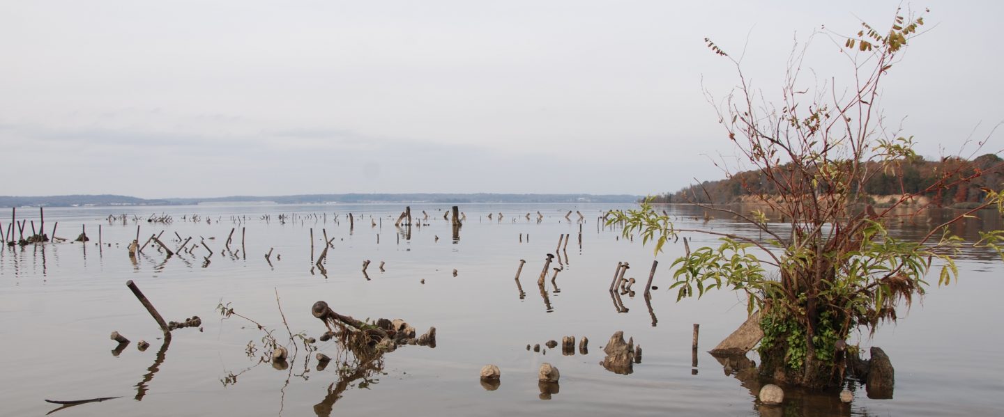
Given Isabel’s high cost and human suffering, it seems almost quaint to survey her effects on Baltimore County’s North Point State Park, a 1,300-acre tract of marsh, woodlands, fields, and bay-side frontage on the Dundalk peninsula between the Patapsco and Back rivers. But Steve Takos Sr., at 80 and after five surgeries in the past eight months, has good reason to visit on this sunny October afternoon. He first came here in 1937 as a duckpin-setter for a nickel a game, and later took tickets for amusement rides. That’s when it was Bay Shore Park, a resort on a trolley line that drew throngs from around the region to play on the water. One way or another, Takos has been working here ever since. When Beth Steel owned the property from 1946 to 1987, he served as a guide for Sparrows Point executives on lunch-hour hunting and fishing trips. Today, he’s a volunteer park ranger. His long past with the property now compels him to see how it fared in the flood.
“Holy Moses! I’ve never seen it this bad,” Takos exclaims as he stands at the foot of Ferry Grove Pier, where a cluster of waterfront buildings once sat, receiving visitors and trade from the Eastern Shore. Isabel tossed around the scattered remnants of the long-gone structures like so many grains of sand, creating high dunes of rock, brick, and Belgian block stretching back into the woods. Nestled among the mounds are hefty chunks from the shattered sea wall and pier, a section of which collapsed in a jumbled mass of cement and twisted rebar. “Thousand-pound boulders were just picked up and thrown” by the wind-driven waves, Takos marvels, adding that “this may have been worse than the storm of 1933,” which tore down the trolley line’s trestle bridge over nearby Shallow Creek.
Takos has already checked out the pounding the 1,000-foot-long fishing pier took (it’s closed indefinitely) and how storm-driven flotsam knocked the support posts of the restored trolley house out of whack. But he’s mystified by what he finds further up the park’s shoreline. Large trees toppled over a retreating bluff onto a newly expanded beach, where roughly 30 yards of high ground fell into the bay. A butte of sandy earth topped with grass and stones, eight feet high and five feet in diameter, was left standing like a sentry on the gouged-out shore. At its foot, a segment of old “corduroy road” was excavated by the bay’s storm-churned waters. Constructed of large timbers set side by side, the road served mule-drawn carts bringing building materials for the Bay Shore trolley line a century ago but has been buried for decades. The sudden reappearance of the corduroy road pleases Takos: “That’s one good thing [Isabel] did. I always said the tracks ran right through here, and there they are.”
He points to where a drowned section of Bay Shore’s sea wall pokes up through the tide a hundred or so yards offshore. Once a stout, six-mile-long barrier, he explains, the wall has since become an increasingly fragmented line of broken cement and rocks that here descends into open water, forming a shallow bay behind it. “There was all high land up to that sea wall,” he remarks while standing on the edge of the bluff. “Lost all of it in 60 years.” Takos has been around over the decades to watch firsthand as the bay swallowed up the land here. With Isabel’s help, it took another big bite.
The day after Takos’ visit to the park, on Oct. 10, a storm of another sort came down from the state’s highest court and took a bite out of the law designed to protect the bay’s shoreline. The 1984 Critical Areas Act governs development in almost 700,000 acres within a 1,000-foot strip around the Chesapeake Bay’s Maryland shoreline and virtually bans new construction inside a 100-foot buffer zone closest to the water–the so-called “critical areas” where new construction is reviewed, guided, and in some cases stopped altogether. In its final word on the case of Lewis vs. Department of Natural Resources, the seven-member Court of Appeals declined to reconsider a July decision that the three dissenting judges say hobbled the act. Unless the state legislature repairs the damage to the law–and it is expected to try in the coming session that starts in January–planning boards in the 16 bay-side counties and 45 municipalities affected by it can expect to see property owners try to exploit the Court of Appeals decision with new building proposals. Already, “it’s seeping into arguments that we are hearing on the local levels,” says Martin Madden, a former Republican state senator from Howard County who in late spring was named chair of the Critical Areas Commission charged with implementing the law.
North Point State Park’s eroding waterfront has a lesson to teach about the Critical Areas Act: Government may try to legislate development along the shore front, but nature bats last. Scientists expect the coming decades to bring more frequent and stronger storms for the Mid-Atlantic, as the bay rises in step with global sea-level rises. If the experts are right, North Point’s history serves as a graphic harbinger of what ultimately can happen to shoreline development: buildings and piers smashed by the sea, once solid ground eaten away and reclaimed by flooding and erosion. By paving the way for more bay-side development, the Appeals Court’s decision on Lewis virtually assures that more property owners will face those inexorable natural forces in the future, likely losing homes, improvements, and raw acreage in the bargain.
“The [Critical Areas] Act says it’s good to move people out of that buffer area for the bay’s sake,” says J. Court Stevenson, an ecologist and sea-level rise expert at the University of Maryland Center for Environmental Sciences near Cambridge. The law, he points out, theoretically gives the Chesapeake more of a chance to rebound from its various environmental ills by discouraging human activity directly on its shoreline. But, he adds, rising seas and violent storms “show that it’s also good to move people out of the buffer for people’s sake.”
Crafting a passable critical-areas bill back in 1984 meant pulling a few of its teeth. Thousands of undeveloped parcels were legally partitioned into buildable lots before the law took effect and grandfathered in, Madden and the Critical Areas Commission’s executive director, Ren Serey, explain in an interview, but there is no way to estimate how many or their combined acreage. And the law designates 5 percent of land as a “resource conservation area,” subject to a low development density of one dwelling per 20 acres, to be reclassified by local planning boards in a “growth allocation” process to allow more intense uses. The law’s untapped–and largely unknown–potential for future shoreline development is enormous. The only way to slow that growth is for legislators to change the law.
The law’s built-in weaknesses are the source of much browbeating from people who expected it to have done more to rein in waterfront development as its second decade begins. State Del. Joan Cadden, an Anne Arundel County Democrat and member of the General Assembly’s joint Committee on Chesapeake Bay Critical Areas, voiced this sentiment with great frustration at a July 7 committee hearing: “How do we allow them to do these things? I thought that’s what we were all about, making sure that kind of development didn’t happen anymore. I thought that is what we were here for.”
“You all need to get some teeth,” chided Calvert County Democrat Del. George Owings III at the hearing. He told the story of how novelist Tom Clancy cleared a wide swath of trees down to the waterfront of his Calvert County property, “and got a tiny little fine.” “Just pay the fine and take the view, that’s what’s happening here,” Owings said.
Madden had an answer to that. “Enforcement is spotty, inconsistent, and deteriorating,” he told the joint committee. “It’s easier [for property owners] to pay a $500 fine and freely develop the property.” His solution: “We will probably look for penalties in the area of $10,000 instead of $500. We will also work to allow the local governments to refer to the commission on a voluntary basis a violation that they feel maybe they just don’t have the ability to handle because they are overwhelmed with other issues.” Madden also pointed out that the commission has no powers to strengthen its rules or enforcement powers: “The legislature has to do that.”
Madden didn’t have an answer to a big-picture gripe from the committee’s co-chair, state Sen. Roy Dyson, a Southern Maryland Democrat: “The truth of the matter is, what has happened with the bay cleanup is that it has stalled. Million-dollar homeowners support the bay cleanup without understanding their own contributions to the problem.”
The contributions Dyson referred to are actually codified as “findings” in the critical-areas act, making it a matter of law in Maryland that human activities like building and tree-clearing and their cumulative effects harm the bay, while minimizing such activity aids in the bay’s restoration. But Dyson’s allegation of hypocrisy among wealthy waterfront property owners underscores one of the law’s most noticeable impacts: rising property values in the critical areas.
The ink had hardly dried from then-Gov. Harry Hughes’ pen before the land rush started on properties within its yet-to-be-drawn border. Prices started going up immediately, and they’ve never stopped. As a result, wealthier people have been supplanting middle-class waterfront owners. “McMansions are springing up where bungalows used to be,” an Anne Arundel County planner puts it. With the monied property owners come lawyers. From 1984 until 1999, the Critical Areas Act went largely unhindered by adverse court decisions. Then, before the Lewis decision came down, three cases hit the Court of Appeals in succession, and the unanimous rulings of the court knocked open loopholes for more development. As a result, the General Assembly in 2002 revisited and strengthened the act.
Enter Edwin Lewis and his lawyer, Raymond Smethurst Jr. of Salisbury. Working for apparel-industry giants Tommy Hilfiger and Polo Ralph Lauren had been good to Lewis, an avid hunter who’s long enjoyed the Eastern Shore at his waterfront estate. In 1999 he added to his idyllic holdings, buying up nearly 300 acres of Wicomico County marshland. In the middle of it is a five-acre hummock, a rise in the marsh with trees growing on it, where in early 2000 Lewis proceeded to build a hunting lodge, four cabins, and a shed–all of it without permits and all of it inside the 100-foot critical area buffer zone.
Construction was almost over before anyone noticed. Once the authorities caught up with Lewis, Smethurst stepped in, bringing his experience working for those accused on the Eastern Shore of breaking land-use laws. Lewis didn’t purposefully break the critical-area rules, Smethurst explained. Then Lewis sought a zoning variance to allow the lodge and one cabin to remain in the buffer area. When it was denied, Lewis had Smethurst appeal it all the way up to the top–and won, because the court ruled there wasn’t sufficient evidence to show the project harmed the environment.
To Ren Serey, who’s been the executive director of the Critical Areas Commission since 1995, the Lewis ruling was a serious blow both to the commission and to zoning laws generally in Maryland. First off, he explains, it shifted the burden of proof from the property owner to the government in assessing the potential harm a project may cause. Thus, instead of requiring property owners to show local planning boards why their projects would not cause harm, it’s now up to the government to show why the project would cause harm. “That’s new,” says Serey, “and in our viewpoint, a significant burden on local government, both in and outside the critical areas, because now they, not the applicant, have to prove the question of harm.”
The ruling also flouted “the self-imposed hardship rule,” Serey argues. Now, the fact that something has already been built without permits, and that the remedy–removing the structure–would be a “self-imposed hardship,” can be used to argue that it should be allowed to stay. “The court even said,” Serey continues, “that the fact that Mr. Lewis actually started constructing these cabins benefited everybody because he could use their construction to prove that he wasn’t causing harm.” Finally, Serey contends that the court overlooked the findings of the legislature about the cumulative human impacts that harm the bay.
Appeals Court Judge Alan Wilner minced no words in his dissenting opinion on the Lewis case, in which he was joined by two other judges. “This was not just a disagreement over a point of law,” he writes of the 4-3 ruling. “In my view . . . the majority Opinion was deliberately designed, and, unless the General Assembly acts swiftly and decisively, may be effective, not only to dismantle the critical areas program but to seriously weaken fundamental zoning and land use controls generally.” Wilner further wrote that the decision was as “an invitation to the very kind of lawless behavior that occurred in this case–ignore the law, destroy the habitat and build where the law does not permit, do it all in secret, and then claim hardship.”
The majority opinion on Lewis plays down the case’s broader impact. But within days after the Lewis decision came down on July 31, Madden recalls, “we had a hearing in Anne Arundel County where a local zoning examiner had a complaint by some neighbors that a person was building their house much larger than had previously existed within the sensitive buffer area. And it was pointed out that this person had already built it, so to tear it down would be a big inconvenience, but it is a self-imposed hardship, so be it. And the hearing examiner made the comment that, ‘Well, until three days ago, I would have thought that was the case.’ I suspect we’re going to hear a lot more of that.”
The build-first, ask-questions-later mentality is alive and well along the bay. Serey doesn’t know the total number of violations found annually, but says construction without permits is a regular occurrence and that they are usually discovered after a neighbor complains. If the Lewis ruling ends up encouraging lawlessness, as Judge Wilner predicts, and if the fines imposed for breaking the act aren’t increased, the mentality is likely to bloom, resulting in even greater investment in bay-side improvements. To Court Stevenson, the University of Maryland sea-level expert, the whole trend is ass-backward.
Stevenson is standing on what he thinks may be one of the highest points in Dorchester County, the waterside lawn of the Horn Point Laboratory near Cambridge. At the bottom of the grassy slope heading down to the banks of the Choptank River is a sea wall, with a tumble of large rocks behind it. Isabel’s flood tide breached both the wall and the rocks, allowing the bay to scour out large patches of earth and grass along the steep riverbank. Stevenson has worked here since 1972 and says he’s never seen a storm do this.
“We really can’t say what will happen with these storms,” he muses, “so that’s why talking about futures is dicey.” But he does know that the seas are warming measurably on on the Atlantic, which is fueling more hurricanes to hit the Mid-Atlantic coast. “We’re now prone to storm activity that 100 years ago we wouldn’t have seen, with hurricanes just lining up from Africa,” he says. “Isabel did this, and it wasn’t even technically a hurricane anymore. Get a category 2 or 3 hurricane in here, and really get a surge in here–instead of seven feet, say, get eight feet–and there’s going to be wholesale damage.”
So the damage from Isabel, Stevenson hopes, will be read as a warning sign to keep new development out of harm’s way. And, in planning circles, that’s exactly how Isabel was interpreted. “There was a large difference between what was forecast in terms of flooding and what ultimately came to pass,” Baltimore City planner Peter Conrad explains. “In some areas of the city and elsewhere, the water came above the 100-year tidal flood line on the maps used to determine the flood zone for insurance and permitting purposes.”
Ultimately, after a lengthy public process that has yet to begin, new maps could move that line farther inland. “We may add another half-foot or foot of elevation on all new construction” in the city’s flood-prone areas in order to reduce potential storm damage in the future. This “will take several years,” Conrad says, but its impact on shoreline development could be significant. “From the city’s perspective,” he concludes, “we want to encourage development along our tidal area, but we need for it to be safe for 50 or 100 years.”
Stevenson’s research has for years now been focused on trying to help planners like Conrad figure out what more storms and flooding could mean in the context of rising sea levels. The observed rise at the Baltimore City tide gauge is 13 inches from 1903 to 2003, but Stevenson says “most of us believe that we’re seeing an acceleration, and that the rise could be two or even three feet in the next century. Unless we get the greenhouse-gas problem under control–because that’s what’s really driving the rise, the warming atmosphere due to greenhouse gases–it’s just going to get harder and harder and harder in low-lying areas.
“But you’ve got to watch yourself when talking about this stuff,” he jokes. “If you start worrying about this too much, people start to wonder about your sanity.”
Stevenson reaches down and uses his index finger to draw in the sand a profile of a house, the shore, and the sea. “Here’s what Jim Titus says we should do,” he begins. Titus is the federal Environmental Protection Agency’s top sea-level expert, and has long been involved with how the issue pertains to the Chesapeake. “He says let the tide come up, move the houses back, and then buy shore front easements to protect the land in between. But it’s not clear where the money for all those easements will come from. I think it’s more likely that people harden the shoreline to keep the sea-level rise out, with sea walls or bulkheads. And that causes all sorts of ecological problems.”
“There are choices that sea-level rise confronts us with,” Jim Titus explained during a seminar at a national coastal-zone management conference held at the Baltimore Convention Center in mid-July. “But they boil down to this question: Are we going to hold back the sea, or are we going to let our wetlands migrate inland?
“In Maryland, property owners can hold back the sea where they choose to hold back the sea,” he continued. “The general policy seems to be to encourage armoring [the shoreline] and discourage coastal development.” But, he pointed out, conservation easements in Maryland–legal arrangements that, for a price, take away development rights from property owners–don’t affect the right to armor the shoreline, so there would have to be a change in the law to use easements to allow inundated wetlands to re-establish themselves further inland. “We simply haven’t yet completely decided what we intend to do,” he concluded.
Kerry Kehoe, who recently came to the Maryland Department of Natural Resources to direct its coastal program, shares Titus’ and Stevenson’s concerns about how to handle sea-level rise. But he also foresees people’s reactions when they get warning signs that the seas are coming too close to home. “Storm surges and flooding will send a message to get out of there,” he predicted at the coastal conference. “The physical impacts will start to make it obvious–erosion, flooding, higher water tables causing contaminated drinking-water supplies.” Along the undeveloped Chesapeake shoreline, Kehoe points out that “there are still plenty of potential wetland-migration areas” where bulkheads have not been constructed. “The bad news is those very same areas are under substantial development pressure–that’s where people want to live.”
That’s also where the Critical Areas Act was intended to limit growth and development. But, in Stevenson’s estimation, the law’s constraints have had limited–and sometimes dubious–effects. “I think it’s had an impact,” he says with a note of irony. “I’m not so sure it’s all positive, though.” The first thing that comes to mind is the land rush back when the law first passed, which created all those untold thousands of grandfathered tracts. Then there’s the issue of wealth and class: Rising land values in the critical areas mean the waterfront is less and less available to the working-class people who have traditionally lived along the bay. And finally, he points out–and Serey and Madden confirm this–the fact that the 1,000-foot critical-area line doesn’t move inland with sea-level rise, but remains based on wetlands maps drawn in 1972. Although the 100-foot buffer line does shift with rising sea-level, property owners are entitled to bulkhead back to the 1972 tide line.
“The act largely ignores the unavoidable issue of sea-level rise,” Stevenson contends, “and ultimately that’s going to reduce the amount of land subject to it.”
“In the long run,” Stevenson says of the Critical Areas Act, “it had a lot of good ideas, good concepts” about what harms the bay and the human role in that harm. But he says it “hasn’t really delivered” the goods in terms of lessening human impacts. “I don’t know exactly, but it seems to me it hasn’t stopped much development, even in the buffer zone.” He’s waiting for local governments to use up their growth allocations–something that Madden says is years away–because then, presumably, much of the new construction on vacant shoreline will cease. “When the growth allocation really runs out, that’s when I’ll be happy,” he says
Madden, though, defends the act’s impacts. Despite the grandfathering and the growth allocations, it still has significant muscle, he says, and the legislature is always free to strengthen however it sees fit. “We’re going to look for Senator Dyson and Delegate [Barbara] Frush to take the lead on that, based on our recommendations.” Dyson and Frush, the oversight committee’s co-chairs, did not return phone calls about possible critical-areas legislation to be introduced in the coming session.
In the meantime, Madden explains, about 2,000 projects go through critical-areas review each year, a process that sends the commission’s staff through a proposal’s details with a fine-tooth comb, looking to make sure the design and construction minimizes harm to the bay. And that process, along with the more stringent requirements in the buffer zone, has made for more sensible, if not less, development.
“It is going to be interesting,” Madden says, “to compare the damage from Isabel to affected properties that were built after the critical area law took effect, as opposed to properties that existed prior to that. Because I think you’ll find that the development that took place after the critical area law, where we protected the buffer as much as possible while still accommodating growth, had much less damage than pre-existing properties that were built within the buffer right up to the shore. There are good environmental reasons to have a buffer . . . but I think Isabel shows that there are good, sound economical reasons to have a buffer also.”
The question is, how protected is that buffer after the Lewis ruling? And if it is in fact gutted, will expensive, newly developed properties soon face the fate of the thousands of homes hit hard by Isabel–and, in the long run, the fate of Bay Shore Park. Sea-level rise and hurricanes will ultimately rule the shape and scope of future shoreline development, but for now, repeats Madden, shoring up the Critical Areas Act is “up to the legislature.”

One thought on “Time and Tide: Will the erosion of Maryland’s Critical Areas Act mean even bigger trouble when the next Isabel comes along?”